Warhem
Warhem
Warrem | |
|---|---|
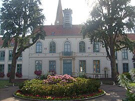 The town hall in Warhem | |
 Coat of arms | |
show Location of Warhem | |
 Warhem | |
| Coordinates: 50°58′35″N 2°29′38″E / 50.9764°N 2.4939°ECoordinates: 50°58′35″N 2°29′38″E / 50.9764°N 2.4939°E | |
| Country | France |
| Region | Hauts-de-France |
| Department | Nord |
| Arrondissement | Dunkerque |
| Canton | Wormhout |
| Intercommunality | Hauts de Flandre |
| Government | |
| • Mayor (2020–2026) | Pierre Bouttemy[1] |
| Area 1 | 27.84 km2 (10.75 sq mi) |
| Population (Jan. 2018)[2] | 2,020 |
| • Density | 73/km2 (190/sq mi) |
| Demonym(s) | Warhemois (es) |
| Time zone | UTC+01:00 (CET) |
| • Summer (DST) | UTC+02:00 (CEST) |
| INSEE/Postal code | 59641 /59380 |
| Elevation | 0–26 m (0–85 ft) (avg. 15 m or 49 ft) |
| 1 French Land Register data, which excludes lakes, ponds, glaciers > 1 km2 (0.386 sq mi or 247 acres) and river estuaries. | |


Warhem (from Flemish; Warrem in modern Dutch spelling) is a commune in the Nord department in northern France, near the border with Belgium.
Politics[]
Presidential Elections 2nd Round[]
| Election | Candidate | Party | % | |
|---|---|---|---|---|
| 2017 | Emmanuel Macron | En Marche! | 51.96 | |
| 2012 | Nicolas Sarkozy | UMP | 55.62 | |
| 2007 | Nicolas Sarkozy | UMP | 53.25 | |
| 2002 | Jacques Chirac | RPR | 80.00 | |
Heraldry[]
 |
The arms of Warhem are blazoned : Chequy argent and sable.
|
Population[]
| Year | Pop. | ±% |
|---|---|---|
| 2006 | 2,029 | — |
| 2007 | 2,029 | +0.0% |
| 2008 | 2,069 | +2.0% |
| 2009 | 2,066 | −0.1% |
| 2010 | 2,064 | −0.1% |
| 2011 | 2,061 | −0.1% |
| 2012 | 2,071 | +0.5% |
| 2013 | 2,063 | −0.4% |
| 2014 | 2,059 | −0.2% |
| 2015 | 2,055 | −0.2% |
| 2016 | 2,051 | −0.2% |
See also[]
References[]
- ^ "Répertoire national des élus: les maires". data.gouv.fr, Plateforme ouverte des données publiques françaises (in French). 2 December 2020.
- ^ "Populations légales 2018". INSEE. 28 December 2020.
- ^ http://www.lemonde.fr/nord-pas-de-calais-picardie/nord,59/warhem,59641/elections/presidentielle-2017/
| Wikimedia Commons has media related to Warhem. |
This Nord geographical article is a stub. You can help Wikipedia by . |
Categories:
- Communes of Nord (French department)
- Nord (French department) geography stubs