Solre-le-Château
Solre-le-Château | |
|---|---|
 A general view of Solre-le-Château | |
 Coat of arms | |
show Location of Solre-le-Château | |
 Solre-le-Château | |
| Coordinates: 50°10′31″N 4°05′33″E / 50.1753°N 4.0925°ECoordinates: 50°10′31″N 4°05′33″E / 50.1753°N 4.0925°E | |
| Country | France |
| Region | Hauts-de-France |
| Department | Nord |
| Arrondissement | Avesnes-sur-Helpe |
| Canton | Fourmies |
| Intercommunality | |
| Government | |
| • Mayor (2020–2026) | Patrick Dehen |
| Area 1 | 13.76 km2 (5.31 sq mi) |
| Population (Jan. 2018)[1] | 1,797 |
| • Density | 130/km2 (340/sq mi) |
| Time zone | UTC+01:00 (CET) |
| • Summer (DST) | UTC+02:00 (CEST) |
| INSEE/Postal code | 59572 /59740 |
| Elevation | 168–236 m (551–774 ft) (avg. 200 m or 660 ft) |
| 1 French Land Register data, which excludes lakes, ponds, glaciers > 1 km2 (0.386 sq mi or 247 acres) and river estuaries. | |


Solre-le-Château (French pronunciation: [sɔʁ lə ʃato] (![]() listen)) is a commune in the Nord department in northern France.
listen)) is a commune in the Nord department in northern France.
Heraldry[]
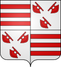 |
The arms of Solre-le-Château are blazoned : Quarterly 1&4: Argent, 3 fesses gules; 2&3: Argent, 3 wagoner's axes top 2 addorsed gules. [2](Bermerain, Étrœungt, Féron, Ferrière-la-Grande, Lez-Fontaine, Rousies, Solre-le-Château and Solrinnes use the same arms.)
|
See also[]
References[]
- ^ "Populations légales 2018". INSEE. 28 December 2020.
- ^ Arms of the families of Croÿ-Solre and Croÿ-Renty quartered
| Wikimedia Commons has media related to Solre-le-Château. |
| show Authority control |
|---|
This Nord geographical article is a stub. You can help Wikipedia by . |
Categories:
- Communes of Nord (French department)
- Nord (French department) geography stubs