Baives
Baives | |
|---|---|
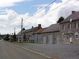 A view within Baives | |
 Coat of arms | |
show Location of Baives | |
 Baives | |
| Coordinates: 50°03′49″N 4°12′14″E / 50.0636°N 4.2039°ECoordinates: 50°03′49″N 4°12′14″E / 50.0636°N 4.2039°E | |
| Country | France |
| Region | Hauts-de-France |
| Department | Nord |
| Arrondissement | Avesnes-sur-Helpe |
| Canton | Fourmies |
| Intercommunality | |
| Government | |
| • Mayor (2020–2026) | Claude Gary[1] |
| Area 1 | 7.98 km2 (3.08 sq mi) |
| Population (Jan. 2018)[2] | 168 |
| • Density | 21/km2 (55/sq mi) |
| Time zone | UTC+01:00 (CET) |
| • Summer (DST) | UTC+02:00 (CEST) |
| INSEE/Postal code | 59045 /59132 |
| Elevation | 184–239 m (604–784 ft) (avg. 250 m or 820 ft) |
| 1 French Land Register data, which excludes lakes, ponds, glaciers > 1 km2 (0.386 sq mi or 247 acres) and river estuaries. | |


Baives is a commune in the Nord department in northern France. It is 10 km (6.2 mi) northeast of Fourmies and 25 km (16 mi) southeast of Maubeuge.
Population[]
|
|
Heraldry[]
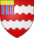 |
The arms of Baives are blazoned : Gules, 2 fesses embattled counterembattled argent, overall on a canton Gules, 3 pales vair and a chief Or. (Baives and Willies use the same arms.)
|
See also[]
References[]
- ^ "Répertoire national des élus: les maires". data.gouv.fr, Plateforme ouverte des données publiques françaises (in French). 2 December 2020.
- ^ "Populations légales 2018". INSEE. 28 December 2020.
| Wikimedia Commons has media related to Baives. |
This Nord geographical article is a stub. You can help Wikipedia by . |
Categories:
- Communes of Nord (French department)
- Nord (French department) geography stubs