Herlies
From Wikipedia, the free encyclopedia
Commune in Hauts-de-France, France
Herlies | |
|---|---|
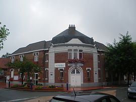 The town hall in Herlies | |
 Coat of arms | |
 Herlies  Herlies | |
Coordinates:  50°34′44″N 2°51′18″E / 50.5789°N 2.855°E / 50.5789; 2.855Coordinates: 50°34′44″N 2°51′18″E / 50.5789°N 2.855°E / 50.5789; 2.855 50°34′44″N 2°51′18″E / 50.5789°N 2.855°E / 50.5789; 2.855Coordinates: 50°34′44″N 2°51′18″E / 50.5789°N 2.855°E / 50.5789; 2.855 | |
| Country | France |
| Region | Hauts-de-France |
| Department | Nord |
| Arrondissement | Lille |
| Canton | Annœullin |
| Intercommunality | Métropole Européenne de Lille |
| Government | |
| • Mayor (2014-2020) | Marie-Françoise Auger |
| Area 1 | 7.11 km2 (2.75 sq mi) |
| Population (Jan. 2018)[1] | 2,396 |
| • Density | 340/km2 (870/sq mi) |
| Time zone | UTC+01:00 (CET) |
| • Summer (DST) | UTC+02:00 (CEST) |
| INSEE/Postal code | 59303 /59134 |
| Elevation | 24–41 m (79–135 ft) (avg. 37 m or 121 ft) |
| 1 French Land Register data, which excludes lakes, ponds, glaciers > 1 km2 (0.386 sq mi or 247 acres) and river estuaries. | |

Herlies is a commune in the Nord department in northern France. It is part of the Métropole Européenne de Lille.
Heraldry[]
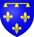 |
The arms of Herlies are blazoned : Azure, 3 fleurs de lys, in chief a label of three points Or.
|
See also[]
References[]
- ^ "Populations légales 2018". INSEE. 28 December 2020.
| Wikimedia Commons has media related to Herlies. |
show
| ||
|---|---|---|
|  | |
show
| |
|---|---|
|
This Nord geographical article is a stub. You can help Wikipedia by . |
- v
- t
Retrieved from ""
Categories:
- Communes of Nord (French department)
- Nord (French department) geography stubs
Hidden categories:
- Articles with short description
- Short description is different from Wikidata
- Infobox mapframe without OSM relation ID on Wikidata
- Coordinates on Wikidata
- Pages using infobox settlement with image map1 but not image map
- Commons category link from Wikidata
- Articles with BNF identifiers
- All stub articles
- Pages using the Kartographer extension