Tourmignies
Tourmignies | |
|---|---|
 St Peter's church, Tourmignies | |
 Coat of arms | |
show Location of Tourmignies | |
 Tourmignies | |
| Coordinates: 50°30′27″N 3°05′06″E / 50.5075°N 3.085°ECoordinates: 50°30′27″N 3°05′06″E / 50.5075°N 3.085°E | |
| Country | France |
| Region | Hauts-de-France |
| Department | Nord |
| Arrondissement | Lille |
| Canton | Templeuve |
| Intercommunality | Pévèle-Carembault |
| Government | |
| • Mayor (2020–2026) | Alain Duchesne[1] |
| Area 1 | 2.03 km2 (0.78 sq mi) |
| Population (Jan. 2018)[2] | 895 |
| • Density | 440/km2 (1,100/sq mi) |
| Time zone | UTC+01:00 (CET) |
| • Summer (DST) | UTC+02:00 (CEST) |
| INSEE/Postal code | 59600 /59551 |
| Elevation | 37–49 m (121–161 ft) (avg. 57 m or 187 ft) |
| 1 French Land Register data, which excludes lakes, ponds, glaciers > 1 km2 (0.386 sq mi or 247 acres) and river estuaries. | |


Tourmignies is a commune in the Nord department and Hauts-de-France region of northern France.
Population[]
| Year | Pop. | ±% |
|---|---|---|
| 1946 | 505 | — |
| 1954 | 509 | +0.8% |
| 1962 | 534 | +4.9% |
| 1968 | 505 | −5.4% |
| 1975 | 576 | +14.1% |
| 1982 | 596 | +3.5% |
| 1990 | 615 | +3.2% |
| 1999 | 756 | +22.9% |
| 2004 | 707 | −6.5% |
| 2009 | 686 | −3.0% |
| 2014 | 837 | +22.0% |
| 2015 | 867 | +3.6% |
Heraldry[]
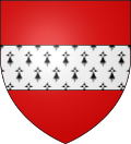 |
The arms of Tourmignies are blazoned : Gules, a fess ermine.
|
See also[]
References[]
- ^ "Répertoire national des élus: les maires". data.gouv.fr, Plateforme ouverte des données publiques françaises (in French). 2 December 2020.
- ^ "Populations légales 2018". INSEE. 28 December 2020.
External links[]
| Wikimedia Commons has media related to Tourmignies. |
This Nord geographical article is a stub. You can help Wikipedia by . |
Categories:
- Communes of Nord (French department)
- Nord (French department) geography stubs