Bettrechies
Bettrechies | |
|---|---|
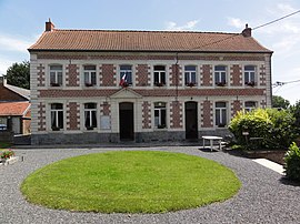 The town hall in Bettrechies | |
 Coat of arms | |
show Location of Bettrechies | |
 Bettrechies | |
| Coordinates: 50°19′31″N 3°44′41″E / 50.3253°N 3.7447°ECoordinates: 50°19′31″N 3°44′41″E / 50.3253°N 3.7447°E | |
| Country | France |
| Region | Hauts-de-France |
| Department | Nord |
| Arrondissement | Avesnes-sur-Helpe |
| Canton | Aulnoye-Aymeries |
| Intercommunality | |
| Government | |
| • Mayor (2014-2020) | Michel Tahon |
| Area 1 | 3.36 km2 (1.30 sq mi) |
| Population (Jan. 2018)[1] | 255 |
| • Density | 76/km2 (200/sq mi) |
| Time zone | UTC+01:00 (CET) |
| • Summer (DST) | UTC+02:00 (CEST) |
| INSEE/Postal code | 59077 /59570 |
| Elevation | 67–129 m (220–423 ft) (avg. 100 m or 330 ft) |
| 1 French Land Register data, which excludes lakes, ponds, glaciers > 1 km2 (0.386 sq mi or 247 acres) and river estuaries. | |


Bettrechies is a commune in the Nord department in northern France.
Population[]
| Year | Pop. | ±% |
|---|---|---|
| 1793 | 220 | — |
| 1800 | 219 | −0.5% |
| 1806 | 251 | +14.6% |
| 1821 | 255 | +1.6% |
| 1831 | 304 | +19.2% |
| 1836 | 345 | +13.5% |
| 1841 | 348 | +0.9% |
| 1846 | 339 | −2.6% |
| 1851 | 337 | −0.6% |
| 1856 | 329 | −2.4% |
| 1861 | 335 | +1.8% |
| 1866 | 331 | −1.2% |
| 1872 | 336 | +1.5% |
| 1876 | 340 | +1.2% |
| 1881 | 362 | +6.5% |
| 1886 | 376 | +3.9% |
| 1891 | 378 | +0.5% |
| 1896 | 411 | +8.7% |
| 1901 | 418 | +1.7% |
| 1906 | 436 | +4.3% |
| 1911 | 413 | −5.3% |
| 1921 | 378 | −8.5% |
| 1926 | 358 | −5.3% |
| 1931 | 340 | −5.0% |
| 1936 | 339 | −0.3% |
| 1946 | 306 | −9.7% |
| 1954 | 279 | −8.8% |
| 1962 | 297 | +6.5% |
| 1968 | 270 | −9.1% |
| 1975 | 253 | −6.3% |
| 1982 | 286 | +13.0% |
| 1990 | 235 | −17.8% |
| 1999 | 246 | +4.7% |
| 2005 | 243 | −1.2% |
| 2006 | 243 | +0.0% |
| 2009 | 245 | +0.8% |
| 2010 | 247 | +0.8% |
| 2015 | 254 | +2.8% |
Heraldry[]
 |
The arms of Bettrechies are blazoned : Or, a cross engrailed gules. (Artres, Bettrechies, Cerfontaine, Denain, Eth, Lesquin, Obies, Quérénaing, Semousies, Wambrechies and Warlaing use the same arms.)
|
See also[]
References[]
- ^ "Populations légales 2018". INSEE. 28 December 2020.
| Wikimedia Commons has media related to Bettrechies. |
This Nord geographical article is a stub. You can help Wikipedia by . |
Categories:
- Communes of Nord (French department)
- Nord (French department) geography stubs