Warlaing
Warlaing | |
|---|---|
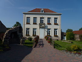 The town hall | |
 Coat of arms | |
show Location of Warlaing | |
 Warlaing | |
| Coordinates: 50°24′40″N 3°19′34″E / 50.4111°N 3.3261°ECoordinates: 50°24′40″N 3°19′34″E / 50.4111°N 3.3261°E | |
| Country | France |
| Region | Hauts-de-France |
| Department | Nord |
| Arrondissement | Douai |
| Canton | Sin-le-Noble |
| Intercommunality | Cœur d'Ostrevent |
| Government | |
| • Mayor (2020–2026) | Patrice Bricout[1] |
| Area 1 | 3.89 km2 (1.50 sq mi) |
| Population (Jan. 2018)[2] | 580 |
| • Density | 150/km2 (390/sq mi) |
| Time zone | UTC+01:00 (CET) |
| • Summer (DST) | UTC+02:00 (CEST) |
| INSEE/Postal code | 59642 /59870 |
| Elevation | 16–19 m (52–62 ft) (avg. 17 m or 56 ft) |
| 1 French Land Register data, which excludes lakes, ponds, glaciers > 1 km2 (0.386 sq mi or 247 acres) and river estuaries. | |


Warlaing is a commune in the Nord department in northern France.
Heraldry[]
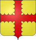 |
The arms of Warlaing are blazoned : Or, a cross engrailed gules. (Artres, Bettrechies, Cerfontaine, Denain, Eth, Lesquin, Obies, Quérénaing, Semousies, Wambrechies and Warlaing use the same arms.)
|
Population[]
| Year | Pop. | ±% |
|---|---|---|
| 2006 | 549 | — |
| 2007 | 562 | +2.4% |
| 2008 | 572 | +1.8% |
| 2009 | 578 | +1.0% |
| 2010 | 566 | −2.1% |
| 2011 | 554 | −2.1% |
| 2012 | 542 | −2.2% |
| 2013 | 553 | +2.0% |
| 2014 | 551 | −0.4% |
| 2015 | 560 | +1.6% |
| 2016 | 570 | +1.8% |
Sites and monuments[]
- Church of our Lady of the Assumption, built around 1852 by Lille architect , who was the designer of many religious buildings in northern France, including the Notre-Dame de la Treille cathedral.
- The Château de Warlaing, now in ruins, was destroyed by the armies of Louis XIV.
- The Scarpe, its lock and bridge.

The road into Warlaing

The Church of Our Lady of the Assumption

The grotto of Lourdes
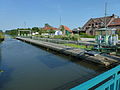
The lock of the Scarpe

The bascule bridge on the Scarpe


See also[]
References[]
- ^ "Répertoire national des élus: les maires". data.gouv.fr, Plateforme ouverte des données publiques françaises (in French). 2 December 2020.
- ^ "Populations légales 2018". INSEE. 28 December 2020.
| Wikimedia Commons has media related to Warlaing. |
This Nord geographical article is a stub. You can help Wikipedia by . |
Categories:
- Communes of Nord (French department)
- Nord (French department) geography stubs