Hardifort
Hardifort
Hardefoort / Hardenvoorde | |
|---|---|
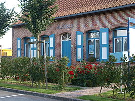 The town hall in Hardifort | |
 Coat of arms | |
show Location of Hardifort | |
 Hardifort | |
| Coordinates: 50°49′14″N 2°29′11″E / 50.8206°N 2.4864°ECoordinates: 50°49′14″N 2°29′11″E / 50.8206°N 2.4864°E | |
| Country | France |
| Region | Hauts-de-France |
| Department | Nord |
| Arrondissement | Dunkerque |
| Canton | Wormhout |
| Intercommunality | |
| Government | |
| • Mayor (2014-2020) | Bernard Delassus |
| Area 1 | 6.14 km2 (2.37 sq mi) |
| Population (Jan. 2018)[1] | 383 |
| • Density | 62/km2 (160/sq mi) |
| Demonym(s) | Hardifortois (es) |
| Time zone | UTC+01:00 (CET) |
| • Summer (DST) | UTC+02:00 (CEST) |
| INSEE/Postal code | 59282 /59670 |
| Elevation | 24–130 m (79–427 ft) (avg. 15 m or 49 ft) |
| 1 French Land Register data, which excludes lakes, ponds, glaciers > 1 km2 (0.386 sq mi or 247 acres) and river estuaries. | |


Hardifort (Dutch: Hardefoort / Hardenvoorde) is a commune in the Nord department in northern France.
Politics[]
Presidential Elections 2nd Round[]
| Election | Winning Candidate | Party | % | |
|---|---|---|---|---|
| 2017 | Emmanuel Macron | En Marche! | 52.31 | |
| 2012 | Nicolas Sarkozy | UMP | 54.22 | |
| 2007 | Nicolas Sarkozy | UMP | 52.14 | |
| 2002 | Jacques Chirac | RPR | 81.82 | |
Heraldry[]
 |
The arms of Hardifort are blazoned : Argent, 3 horns sable tied gules. (Hardifort, Merris and Oudezeele use the same arms.)
|
See also[]
References[]
- ^ "Populations légales 2018". INSEE. 28 December 2020.
- ^ http://www.lemonde.fr/data/france/presidentielle-2017//
| Wikimedia Commons has media related to Hardifort. |
This Nord geographical article is a stub. You can help Wikipedia by . |
Categories:
- Communes of Nord (French department)
- Nord (French department) geography stubs