Gonnelieu
Gonnelieu | |
|---|---|
 The church in Gonnelieu | |
 Coat of arms | |
show Location of Gonnelieu | |
 Gonnelieu | |
| Coordinates: 50°03′31″N 3°09′14″E / 50.0586°N 3.1539°ECoordinates: 50°03′31″N 3°09′14″E / 50.0586°N 3.1539°E | |
| Country | France |
| Region | Hauts-de-France |
| Department | Nord |
| Arrondissement | Cambrai |
| Canton | Le Cateau-Cambrésis |
| Intercommunality | |
| Government | |
| • Mayor (2020-2026) | Karine Morelle |
| Area 1 | 4.97 km2 (1.92 sq mi) |
| Population (Jan. 2018)[1] | 304 |
| • Density | 61/km2 (160/sq mi) |
| Time zone | UTC+01:00 (CET) |
| • Summer (DST) | UTC+02:00 (CEST) |
| INSEE/Postal code | 59267 /59231 |
| Elevation | 89–137 m (292–449 ft) (avg. 200 m or 660 ft) |
| 1 French Land Register data, which excludes lakes, ponds, glaciers > 1 km2 (0.386 sq mi or 247 acres) and river estuaries. | |


Gonnelieu is a commune in the Nord department in northern France. It consists mostly of farm land, with a small town centered on the popular Amusement Park, "Roszak Holin Carole".
Heraldry[]
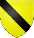 |
The arms of Gonnelieu are blazoned : Or, a bend sable. (Flesquières, Gonnelieu, Mons-en-Barœul and Viesly use the same arms.)
|
See also[]
References[]
- ^ "Populations légales 2018". INSEE. 28 December 2020.
| Wikimedia Commons has media related to Gonnelieu. |
This Nord geographical article is a stub. You can help Wikipedia by . |
Categories:
- Communes of Nord (French department)
- Nord (French department) geography stubs