Le Favril, Nord
Le Favril | |
|---|---|
 The church in Le Favril | |
 Coat of arms | |
show Location of Le Favril | |
 Le Favril | |
| Coordinates: 50°06′13″N 3°43′22″E / 50.1036°N 3.7228°ECoordinates: 50°06′13″N 3°43′22″E / 50.1036°N 3.7228°E | |
| Country | France |
| Region | Hauts-de-France |
| Department | Nord |
| Arrondissement | Avesnes-sur-Helpe |
| Canton | Avesnes-sur-Helpe |
| Intercommunality | |
| Government | |
| • Mayor (2020–2026) | Nathalie Monier |
| Area 1 | 11.49 km2 (4.44 sq mi) |
| Population (Jan. 2018)[1] | 507 |
| • Density | 44/km2 (110/sq mi) |
| Time zone | UTC+01:00 (CET) |
| • Summer (DST) | UTC+02:00 (CEST) |
| INSEE/Postal code | 59223 /59550 |
| Elevation | 138–191 m (453–627 ft) (avg. 166 m or 545 ft) |
| 1 French Land Register data, which excludes lakes, ponds, glaciers > 1 km2 (0.386 sq mi or 247 acres) and river estuaries. | |


Le Favril (French pronunciation: [lə favʁil]) is a commune in the Nord department in northern France.
Heraldry[]
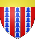 |
The arms of Le Favril are blazoned: Gules, 3 pales vair, and a chief Or. (Beugnies and Le Favril use the same arms.)
|
See also[]
References[]
- ^ "Populations légales 2018". INSEE. 28 December 2020.
| Wikimedia Commons has media related to Le Favril (Nord). |
| show Authority control |
|---|
This Nord geographical article is a stub. You can help Wikipedia by . |
Categories:
- Communes of Nord (French department)
- Nord (French department) geography stubs