Montrécourt
Montrécourt | |
|---|---|
 The church in Montrécourt | |
 Coat of arms | |
show Location of Montrécourt | |
 Montrécourt | |
| Coordinates: 50°13′59″N 3°27′07″E / 50.2331°N 3.4519°ECoordinates: 50°13′59″N 3°27′07″E / 50.2331°N 3.4519°E | |
| Country | France |
| Region | Hauts-de-France |
| Department | Nord |
| Arrondissement | Cambrai |
| Canton | Caudry |
| Intercommunality | |
| Government | |
| • Mayor (2020–2026) | Marc Guillez |
| Area 1 | 3.56 km2 (1.37 sq mi) |
| Population (Jan. 2018)[1] | 224 |
| • Density | 63/km2 (160/sq mi) |
| Time zone | UTC+01:00 (CET) |
| • Summer (DST) | UTC+02:00 (CEST) |
| INSEE/Postal code | 59415 /59227 |
| Elevation | 47–85 m (154–279 ft) |
| 1 French Land Register data, which excludes lakes, ponds, glaciers > 1 km2 (0.386 sq mi or 247 acres) and river estuaries. | |


Montrécourt (French pronunciation: [mɔ̃tʁekuʁ]) is a commune in the Nord department in northern France.
It is one of the smallest, least populated communes of Nord.
Heraldry[]
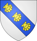 |
The arms of Montrécourt are blazoned : Argent, on a bend azure, 3 escallops bendwise Or. (Awoingt and Montrécourt use the same arms.)
|
See also[]
References[]
- ^ "Populations légales 2018". INSEE. 28 December 2020.
| Wikimedia Commons has media related to Montrécourt. |
This Nord geographical article is a stub. You can help Wikipedia by . |
Categories:
- Communes of Nord (French department)
- Nord (French department) geography stubs