Râches
Râches | |
|---|---|
 The Râches bridge | |
 Coat of arms | |
show Location of Râches | |
 Râches | |
| Coordinates: 50°25′03″N 3°08′15″E / 50.4175°N 3.1375°ECoordinates: 50°25′03″N 3°08′15″E / 50.4175°N 3.1375°E | |
| Country | France |
| Region | Hauts-de-France |
| Department | Nord |
| Arrondissement | Douai |
| Canton | Orchies |
| Intercommunality | Douaisis Agglo |
| Government | |
| • Mayor (2020–2026) | Édith Bourel |
| Area 1 | 4.87 km2 (1.88 sq mi) |
| Population (Jan. 2018)[1] | 2,719 |
| • Density | 560/km2 (1,400/sq mi) |
| Time zone | UTC+01:00 (CET) |
| • Summer (DST) | UTC+02:00 (CEST) |
| INSEE/Postal code | 59486 /59194 |
| Elevation | 17–44 m (56–144 ft) (avg. 21 m or 69 ft) |
| 1 French Land Register data, which excludes lakes, ponds, glaciers > 1 km2 (0.386 sq mi or 247 acres) and river estuaries. | |


Râches is a commune in the Nord department in northern France.
Population[]
| Year | Pop. | ±% |
|---|---|---|
| 2005 | 2,744 | — |
| 2006 | 2,735 | −0.3% |
| 2007 | 2,731 | −0.1% |
| 2008 | 2,734 | +0.1% |
| 2009 | 2,737 | +0.1% |
| 2010 | 2,740 | +0.1% |
| 2011 | 2,722 | −0.7% |
| 2012 | 2,715 | −0.3% |
| 2013 | 2,720 | +0.2% |
| 2014 | 2,722 | +0.1% |
| 2015 | 2,723 | +0.0% |
| 2016 | 2,738 | +0.6% |
Heraldry[]
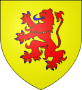 |
The arms of Râches are blazoned : Or, a lion gules, armed and langued azure. (cf Pont-l'Abbé, Escarmain and Haussy)
|
See also[]
References[]
- ^ "Populations légales 2018". INSEE. 28 December 2020.
| Wikimedia Commons has media related to Râches. |
| Authority control |
|
|---|
This Nord geographical article is a stub. You can help Wikipedia by . |
Categories:
- Communes of Nord (French department)
- Nord (French department) geography stubs