Écuélin
Écuélin | |
|---|---|
 The town hall in Écuélin | |
 Coat of arms | |
Location of Écuélin  | |
 Écuélin | |
| Coordinates: 50°11′41″N 3°54′29″E / 50.1947°N 3.9081°ECoordinates: 50°11′41″N 3°54′29″E / 50.1947°N 3.9081°E | |
| Country | France |
| Region | Hauts-de-France |
| Department | Nord |
| Arrondissement | Avesnes-sur-Helpe |
| Canton | Aulnoye-Aymeries |
| Intercommunality | CA Maubeuge Val de Sambre |
| Government | |
| • Mayor (2020–2026) | Emmanuelle Delabre |
| Area 1 | 3.4 km2 (1.3 sq mi) |
| Population (Jan. 2018)[1] | 137 |
| • Density | 40/km2 (100/sq mi) |
| Time zone | UTC+01:00 (CET) |
| • Summer (DST) | UTC+02:00 (CEST) |
| INSEE/Postal code | 59188 /59620 |
| Elevation | 150–185 m (492–607 ft) (avg. 181 m or 594 ft) |
| 1 French Land Register data, which excludes lakes, ponds, glaciers > 1 km2 (0.386 sq mi or 247 acres) and river estuaries. | |


Écuélin (French pronunciation: [ekɥelɛ̃]) is a commune in the Nord department in northern France.
Heraldry[]
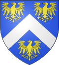 |
The arms of Écuélin are blazoned : Azure, a chevron argent between 3 eagles Or langued and armed gules. (Dompierre-sur-Helpe and Écuélin use the same arms.)
|
See also[]
References[]
- ^ "Populations légales 2018". The National Institute of Statistics and Economic Studies. 28 December 2020.
| Wikimedia Commons has media related to Écuélin. |
|
This Nord geographical article is a stub. You can help Wikipedia by . |
Categories:
- Communes of Nord (French department)
- Nord (French department) geography stubs