Étrœungt
show This article may be expanded with text translated from the corresponding article in French. (July 2012) Click [show] for important translation instructions. |
This article needs additional citations for verification. (July 2012) |
Étroeungt | |
|---|---|
 A view within Étrœungt | |
 Coat of arms | |
show Location of Étroeungt | |
 Étroeungt | |
| Coordinates: 50°03′29″N 3°55′42″E / 50.0581°N 3.9283°ECoordinates: 50°03′29″N 3°55′42″E / 50.0581°N 3.9283°E | |
| Country | France |
| Region | Hauts-de-France |
| Department | Nord |
| Arrondissement | Avesnes-sur-Helpe |
| Canton | Avesnes-sur-Helpe |
| Intercommunality | Cœur de l'Avesnois |
| Government | |
| • Mayor (2020–2026) | Vincent Justice[1] |
| Area 1 | 25.1 km2 (9.7 sq mi) |
| Population (Jan. 2018)[2] | 1,315 |
| • Density | 52/km2 (140/sq mi) |
| Time zone | UTC+01:00 (CET) |
| • Summer (DST) | UTC+02:00 (CEST) |
| INSEE/Postal code | 59218 /59219 |
| Elevation | 148–217 m (486–712 ft) (avg. 385 m or 1,263 ft) |
| 1 French Land Register data, which excludes lakes, ponds, glaciers > 1 km2 (0.386 sq mi or 247 acres) and river estuaries. | |


Étrœungt (French pronunciation: [e.tʁœ̃]) is a commune in the Nord department in northern France.
Geography[]
The river Helpe Mineure (one of Sambre's affluents) runs through the village. The river is subject to occasional flooding. Étrœungt is bordered by ten other communes, including two from Aisne department: Avesnelles, Boulogne-sur-Helpe, Féron, Floyon, Haut-Lieu, La Flamengrie (Aisne), Larouillies, Rainsars, Rocquigny (Aisne), Sémeries. The nearest train station is (SNCF) Avesnes-sur-Helpe. It is 110 km from Lille (Préfecture du Nord), Brussels and Reims (Marne); 55 km from Valenciennes, Laon, Mons and Charleroi; 22 km from Maubeuge; 10 km from Fourmies and 7 km from Avesnes-sur-Helpe. Highways leading to Étrœungt are the RN2 from Paris to Brussels. Belgium is just 15 km away.
Heraldry[]
 |
The arms of Étrœungt are blazoned : Quarterly 1&4: Argent, 3 fesses gules; 2&3: Argent, 3 wagoner's axes top 2 addorsed gules. [3](Bermerain, Étrœungt, Féron, Ferrière-la-Grande, Lez-Fontaine, Rousies, Solre-le-Château and Solrinnes use the same arms.)
|
Gallery[]

Road

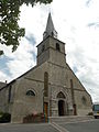
Étrœungt Church
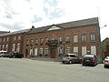
Town Hall
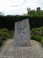
Memorial to the Algerian War Casualties

Stadium


See also[]
References[]
- ^ "Répertoire national des élus: les maires". data.gouv.fr, Plateforme ouverte des données publiques françaises (in French). 2 December 2020.
- ^ "Populations légales 2018". INSEE. 28 December 2020.
- ^ Arms of the families of Croÿ-Solre and Croÿ-Renty quartered
| Wikimedia Commons has media related to Étrœungt. |
| Authority control |
|
|---|
This Nord geographical article is a stub. You can help Wikipedia by . |
- Communes of Nord (French department)
- Nord (French department) geography stubs