Cartignies
Cartignies | |
|---|---|
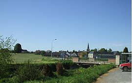 A general view of Cartignies | |
 Coat of arms | |
show Location of Cartignies | |
 Cartignies | |
| Coordinates: 50°05′36″N 3°50′48″E / 50.0933°N 3.8467°ECoordinates: 50°05′36″N 3°50′48″E / 50.0933°N 3.8467°E | |
| Country | France |
| Region | Hauts-de-France |
| Department | Nord |
| Arrondissement | Avesnes-sur-Helpe |
| Canton | Avesnes-sur-Helpe |
| Intercommunality | |
| Government | |
| • Mayor (2020–2026) | Sabine Caufapé-Soumier |
| Area 1 | 26.41 km2 (10.20 sq mi) |
| Population (Jan. 2018)[1] | 1,245 |
| • Density | 47/km2 (120/sq mi) |
| Time zone | UTC+01:00 (CET) |
| • Summer (DST) | UTC+02:00 (CEST) |
| INSEE/Postal code | 59134 /59244 |
| Elevation | 140–213 m (459–699 ft) (avg. 150 m or 490 ft) |
| 1 French Land Register data, which excludes lakes, ponds, glaciers > 1 km2 (0.386 sq mi or 247 acres) and river estuaries. | |


Cartignies (French pronunciation: [kaʁtiɲi]) is a commune in the Nord department in northern France.
Heraldry[]
 |
The arms of Cartignies are blazoned : Bendy Or and gules. (Avesnes-sur-Helpe, Cartignies, Damousies, Dimechaux, Dimont, Felleries, Larouillies, Lomme, and Ramousies use the same arms.)
|
See also[]
References[]
- ^ "Populations légales 2018". INSEE. 28 December 2020.
| Wikimedia Commons has media related to Cartignies. |
| show Authority control |
|---|
This Nord geographical article is a stub. You can help Wikipedia by . |
Categories:
- Communes of Nord (French department)
- Nord (French department) geography stubs