Gruson
From Wikipedia, the free encyclopedia
show This article may be expanded with text translated from the corresponding article in French. (July 2014) Click [show] for important translation instructions.
|
Commune in Hauts-de-France, France
Gruson | |
|---|---|
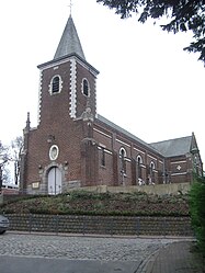 The church at Gruson | |
 Coat of arms | |
 Gruson  Gruson | |
Coordinates:  50°35′43″N 3°12′25″E / 50.5953°N 3.2069°E / 50.5953; 3.2069Coordinates: 50°35′43″N 3°12′25″E / 50.5953°N 3.2069°E / 50.5953; 3.2069 50°35′43″N 3°12′25″E / 50.5953°N 3.2069°E / 50.5953; 3.2069Coordinates: 50°35′43″N 3°12′25″E / 50.5953°N 3.2069°E / 50.5953; 3.2069 | |
| Country | France |
| Region | Hauts-de-France |
| Department | Nord |
| Arrondissement | Lille |
| Canton | Templeuve |
| Intercommunality | Métropole Européenne de Lille |
| Government | |
| • Mayor (2020–2026) | Olivier Turpin |
| Area 1 | 3.13 km2 (1.21 sq mi) |
| Population (Jan. 2018)[1] | 1,288 |
| • Density | 410/km2 (1,100/sq mi) |
| Time zone | UTC+01:00 (CET) |
| • Summer (DST) | UTC+02:00 (CEST) |
| INSEE/Postal code | 59275 /59152 |
| Elevation | 24–53 m (79–174 ft) (avg. 50 m or 160 ft) |
| Website | https://www.mairie-gruson.fr/ |
| 1 French Land Register data, which excludes lakes, ponds, glaciers > 1 km2 (0.386 sq mi or 247 acres) and river estuaries. | |

Gruson is a commune in the Nord department in northern France.
It is part of the Métropole Européenne de Lille.
Heraldry[]
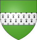 |
The arms of Gruson are blazoned : Vert, a fess ermine. (Oignies, Beaucamps-Ligny, Estrées, Gruson and Wicres use the same arms.)
|
See also[]
References[]
- ^ "Populations légales 2018". INSEE. 28 December 2020.
| Wikimedia Commons has media related to Gruson. |
show
| ||
|---|---|---|
|  | |
show
| |
|---|---|
|
This Nord geographical article is a stub. You can help Wikipedia by . |
- v
- t
Retrieved from ""
Categories:
- Communes of Nord (French department)
- Nord (French department) geography stubs
Hidden categories:
- Articles to be expanded from July 2014
- All articles to be expanded
- Geography articles needing translation from French Wikipedia
- Articles with short description
- Short description is different from Wikidata
- Coordinates on Wikidata
- Pages using infobox settlement with image map1 but not image map
- Commons category link from Wikidata
- Articles with GND identifiers
- Articles with VIAF identifiers
- Articles with BNF identifiers
- Articles with MusicBrainz area identifiers
- Articles with WorldCat-VIAF identifiers
- Nord communes articles needing translation from French Wikipedia
- All stub articles
- Pages using the Kartographer extension