Houplines
Houplines | |
|---|---|
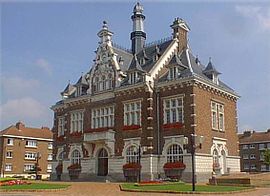 The town hall in Houplines | |
 Coat of arms | |
show Location of Houplines | |
 Houplines | |
| Coordinates: 50°41′29″N 2°54′37″E / 50.6914°N 2.9103°ECoordinates: 50°41′29″N 2°54′37″E / 50.6914°N 2.9103°E | |
| Country | France |
| Region | Hauts-de-France |
| Department | Nord |
| Arrondissement | Lille |
| Canton | Armentières |
| Intercommunality | Métropole Européenne de Lille |
| Government | |
| • Mayor (2020–2026) | Jean-François Legrand[1] |
| Area 1 | 11.32 km2 (4.37 sq mi) |
| Population (Jan. 2018)[2] | 7,770 |
| • Density | 690/km2 (1,800/sq mi) |
| Time zone | UTC+01:00 (CET) |
| • Summer (DST) | UTC+02:00 (CEST) |
| INSEE/Postal code | 59317 /59116 |
| Elevation | 12–20 m (39–66 ft) (avg. 14 m or 46 ft) |
| 1 French Land Register data, which excludes lakes, ponds, glaciers > 1 km2 (0.386 sq mi or 247 acres) and river estuaries. | |


Houplines is a commune in the Nord department in northern France.
It is part of the Métropole Européenne de Lille.
Adjoining the communal (village) cemetery is the Houplines Communal Cemetery Extension, a Commonwealth War Graves Commission maintained cemetery containing the graves of 466 identified casualties, 465 of them Commonwealth servicemen who lost their lives in the area around the village during the First World War.
Houplines maintains a partnership arrangement with the German community of Kirchhundem.
Heraldry[]
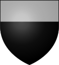 |
The arms of Houplines are blazoned : Sable, a chief argent. (Ennetières-en-Weppes, Houplines and Sailly-lez-Lannoy use the same arms.)
|
See also[]
References[]
- ^ "Répertoire national des élus: les maires". data.gouv.fr, Plateforme ouverte des données publiques françaises (in French). 2 December 2020.
- ^ "Populations légales 2018". INSEE. 28 December 2020.
External links[]
| Wikimedia Commons has media related to Houplines. |

| show Authority control |
|---|
This Nord geographical article is a stub. You can help Wikipedia by . |
Categories:
- Communes of Nord (French department)
- Cemeteries in Nord (French department)
- Nord (French department) geography stubs