La Flamengrie, Nord
La Flamengrie | |
|---|---|
 A general view of La Flamengrie | |
 Coat of arms | |
show Location of La Flamengrie | |
 La Flamengrie | |
| Coordinates: 50°18′58″N 3°43′02″E / 50.3161°N 3.7172°ECoordinates: 50°18′58″N 3°43′02″E / 50.3161°N 3.7172°E | |
| Country | France |
| Region | Hauts-de-France |
| Department | Nord |
| Arrondissement | Avesnes-sur-Helpe |
| Canton | Aulnoye-Aymeries |
| Intercommunality | |
| Government | |
| • Mayor (2014-2020) | Régis Grémont-Naumann |
| Area 1 | 2.03 km2 (0.78 sq mi) |
| Population (Jan. 2018)[1] | 424 |
| • Density | 210/km2 (540/sq mi) |
| Time zone | UTC+01:00 (CET) |
| • Summer (DST) | UTC+02:00 (CEST) |
| INSEE/Postal code | 59232 /59570 |
| Elevation | 108–132 m (354–433 ft) (avg. 120 m or 390 ft) |
| 1 French Land Register data, which excludes lakes, ponds, glaciers > 1 km2 (0.386 sq mi or 247 acres) and river estuaries. | |


La Flamengrie is a commune in the Nord department in northern France.
Heraldry[]
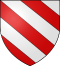 |
The arms of La Flamengrie are blazoned : Bendy argent and gules. (La Flamengrie, Fournes-en-Weppes and Wargnies-le-Grand use the same arms.)
|
See also[]
References[]
- ^ "Populations légales 2018". INSEE. 28 December 2020.
| Wikimedia Commons has media related to La Flamengrie (Nord). |
| show Authority control |
|---|
This Nord geographical article is a stub. You can help Wikipedia by . |
Categories:
- Communes of Nord (French department)
- Nord (French department) geography stubs