Lallaing
Lallaing | |
|---|---|
 The town hall in Lallaing | |
 Coat of arms | |
show Location of Lallaing | |
 Lallaing | |
| Coordinates: 50°23′24″N 3°10′08″E / 50.390°N 3.169°ECoordinates: 50°23′24″N 3°10′08″E / 50.390°N 3.169°E | |
| Country | France |
| Region | Hauts-de-France |
| Department | Nord |
| Arrondissement | Douai |
| Canton | Sin-le-Noble |
| Intercommunality | Douaisis Agglo |
| Government | |
| • Mayor (2020–2026) | Jean-Paul Fontaine[1] |
| Area 1 | 5.99 km2 (2.31 sq mi) |
| Population (Jan. 2018)[2] | 6,297 |
| • Density | 1,100/km2 (2,700/sq mi) |
| Time zone | UTC+01:00 (CET) |
| • Summer (DST) | UTC+02:00 (CEST) |
| INSEE/Postal code | 59327 /59167 |
| Elevation | 16–30 m (52–98 ft) (avg. 20 m or 66 ft) |
| 1 French Land Register data, which excludes lakes, ponds, glaciers > 1 km2 (0.386 sq mi or 247 acres) and river estuaries. | |


Lallaing is a commune in the Nord department in northern France.
Heraldry[]
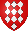 |
The arms of Lallaing are blazoned: Gules, 10 lozenges conjoined argent 3,3,3 and 1. (Fressain, Hergnies, Lallaing and Marpent use the same arms.)
|
See also[]
References[]
- ^ "Répertoire national des élus: les maires". data.gouv.fr, Plateforme ouverte des données publiques françaises (in French). 2 December 2020.
- ^ "Populations légales 2018". INSEE. 28 December 2020.
External links[]
 Media related to Lallaing at Wikimedia Commons
| show Authority control |
|---|
This Nord geographical article is a stub. You can help Wikipedia by . |
Categories:
- Communes of Nord (French department)
- Nord (French department) geography stubs