Louvroil
Louvroil | |
|---|---|
 The town hall | |
 Coat of arms | |
show Location of Louvroil | |
 Louvroil | |
| Coordinates: 50°15′54″N 3°57′36″E / 50.265°N 3.960°ECoordinates: 50°15′54″N 3°57′36″E / 50.265°N 3.960°E | |
| Country | France |
| Region | Hauts-de-France |
| Department | Nord |
| Arrondissement | Avesnes-sur-Helpe |
| Canton | Maubeuge |
| Intercommunality | CA Maubeuge Val de Sambre |
| Government | |
| • Mayor (2020–2026) | Giuseppe Ascone |
| Area 1 | 5.9 km2 (2.3 sq mi) |
| Population (Jan. 2018)[1] | 6,405 |
| • Density | 1,100/km2 (2,800/sq mi) |
| Time zone | UTC+01:00 (CET) |
| • Summer (DST) | UTC+02:00 (CEST) |
| INSEE/Postal code | 59365 /59720 |
| Elevation | 122–175 m (400–574 ft) (avg. 133 m or 436 ft) |
| 1 French Land Register data, which excludes lakes, ponds, glaciers > 1 km2 (0.386 sq mi or 247 acres) and river estuaries. | |


Louvroil is a commune in the Nord department in northern France.
It is about 1.5 km (0.93 mi) southwest of Maubeuge.
Heraldry[]
 |
The traditional arms of Louvroil are blazoned : Or, a double headed eagle sable, beaked and membered Or, langued gules. (Louvroil and Mecquignies use the same arms.).[2]
|
 Arms of Louvroil (modern) |
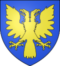
The arms of Louvroil that the town currently uses are blazoned : Azure, a double-headed eagle Or.
|
See also[]
References[]
- ^ "Populations légales 2018". INSEE. 28 December 2020.
- ^ "Newgaso - Toute l'actu rien que l'actu".
| Wikimedia Commons has media related to Louvroil (Nord). |
| show Authority control |
|---|
This Nord geographical article is a stub. You can help Wikipedia by . |
Categories:
- Communes of Nord (French department)
- Nord (French department) geography stubs