Maing
Maing | |
|---|---|
 The town hall in Maing | |
 Coat of arms | |
show Location of Maing | |
 Maing | |
| Coordinates: 50°18′32″N 3°29′10″E / 50.309°N 3.486°ECoordinates: 50°18′32″N 3°29′10″E / 50.309°N 3.486°E | |
| Country | France |
| Region | Hauts-de-France |
| Department | Nord |
| Arrondissement | Valenciennes |
| Canton | Aulnoy-lez-Valenciennes |
| Intercommunality | CA Valenciennes Métropole |
| Government | |
| • Mayor (2020–2026) | Philippe Baudrin[1] |
| Area 1 | 11.68 km2 (4.51 sq mi) |
| Population (Jan. 2018)[2] | 4,061 |
| • Density | 350/km2 (900/sq mi) |
| Time zone | UTC+01:00 (CET) |
| • Summer (DST) | UTC+02:00 (CEST) |
| INSEE/Postal code | 59369 /59233 |
| Elevation | 24–90 m (79–295 ft) (avg. 80 m or 260 ft) |
| 1 French Land Register data, which excludes lakes, ponds, glaciers > 1 km2 (0.386 sq mi or 247 acres) and river estuaries. | |


Maing (French pronunciation: [mɛ̃]) is a commune in the Nord department, northern France.
Fontenelle Abbey was located here.
Heraldry[]
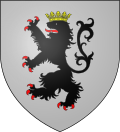 |
The arms of Maing are blazoned : Argent, a lion sable, crowned Or, armed and langued gules. (The arms of Bambecque, Killem and Maing are essentially the same)
|
See also[]
References[]
- ^ "Répertoire national des élus: les maires". data.gouv.fr, Plateforme ouverte des données publiques françaises (in French). 2 December 2020.
- ^ "Populations légales 2018". INSEE. 28 December 2020.
| Wikimedia Commons has media related to Maing. |
| show Authority control |
|---|
This Nord geographical article is a stub. You can help Wikipedia by . |
Categories:
- Communes of Nord (French department)
- Nord (French department) geography stubs