Mecquignies
Mecquignies | |
|---|---|
 The town hall in Mecquignies | |
 Coat of arms | |
show Location of Mecquignies | |
 Mecquignies | |
| Coordinates: 50°16′36″N 3°47′54″E / 50.2767°N 3.7983°ECoordinates: 50°16′36″N 3°47′54″E / 50.2767°N 3.7983°E | |
| Country | France |
| Region | Hauts-de-France |
| Department | Nord |
| Arrondissement | Avesnes-sur-Helpe |
| Canton | Aulnoye-Aymeries |
| Intercommunality | |
| Government | |
| • Mayor (2014-2020) | Joseph Choque |
| Area 1 | 4.78 km2 (1.85 sq mi) |
| Population (Jan. 2018)[1] | 711 |
| • Density | 150/km2 (390/sq mi) |
| Time zone | UTC+01:00 (CET) |
| • Summer (DST) | UTC+02:00 (CEST) |
| INSEE/Postal code | 59396 /59570 |
| Elevation | 118–160 m (387–525 ft) (avg. 150 m or 490 ft) |
| 1 French Land Register data, which excludes lakes, ponds, glaciers > 1 km2 (0.386 sq mi or 247 acres) and river estuaries. | |


Mecquignies is a commune in the Nord department in northern France.
Heraldry[]
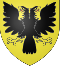 |
The arms of Mecquignies are blazoned : Or, a double headed eagle sable, beaked and membered Or, langued gules. (Louvroil and Mecquignies use the same arms.)
|
See also[]
References[]
- ^ "Populations légales 2018". INSEE. 28 December 2020.
| Wikimedia Commons has media related to Mecquignies. |
| show Authority control |
|---|
This Nord geographical article is a stub. You can help Wikipedia by . |
Categories:
- Communes of Nord (French department)
- Nord (French department) geography stubs