Obrechies
Obrechies | |
|---|---|
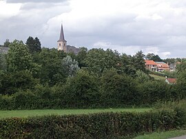 A general view of Obrechies | |
 Coat of arms | |
show Location of Obrechies | |
 Obrechies | |
| Coordinates: 50°13′14″N 4°01′36″E / 50.2206°N 4.0267°ECoordinates: 50°13′14″N 4°01′36″E / 50.2206°N 4.0267°E | |
| Country | France |
| Region | Hauts-de-France |
| Department | Nord |
| Arrondissement | Avesnes-sur-Helpe |
| Canton | Fourmies |
| Intercommunality | CA Maubeuge Val de Sambre |
| Government | |
| • Mayor (2020–2026) | Michel Duveaux[1] |
| Area 1 | 5.45 km2 (2.10 sq mi) |
| Population (Jan. 2018)[2] | 269 |
| • Density | 49/km2 (130/sq mi) |
| Time zone | UTC+01:00 (CET) |
| • Summer (DST) | UTC+02:00 (CEST) |
| INSEE/Postal code | 59442 /59680 |
| Elevation | 138–207 m (453–679 ft) (avg. 175 m or 574 ft) |
| 1 French Land Register data, which excludes lakes, ponds, glaciers > 1 km2 (0.386 sq mi or 247 acres) and river estuaries. | |


Obrechies is a commune in the Nord department in northern France.
Heraldry[]
 |
The arms of Obrechies are blazoned : Azure, 3 fleurs de lys Or. (France and the communes of Estreux, Obrechies use the same arms.)
|
See also[]
References[]
- ^ "Répertoire national des élus: les maires". data.gouv.fr, Plateforme ouverte des données publiques françaises (in French). 2 December 2020.
- ^ "Populations légales 2018". INSEE. 28 December 2020.
| Wikimedia Commons has media related to Obrechies. |
| show Authority control |
|---|
This Nord geographical article is a stub. You can help Wikipedia by . |
Categories:
- Communes of Nord (French department)
- Nord (French department) geography stubs