Pecquencourt
Pecquencourt | |
|---|---|
 The town hall in Pecquencourt | |
 Coat of arms | |
show Location of Pecquencourt | |
 Pecquencourt | |
| Coordinates: 50°22′41″N 3°12′59″E / 50.3781°N 3.2164°ECoordinates: 50°22′41″N 3°12′59″E / 50.3781°N 3.2164°E | |
| Country | France |
| Region | Hauts-de-France |
| Department | Nord |
| Arrondissement | Douai |
| Canton | Sin-le-Noble |
| Intercommunality | Cœur d'Ostrevent |
| Government | |
| • Mayor (2020–2026) | Joël Pierrache[1] |
| Area 1 | 9.6 km2 (3.7 sq mi) |
| Population (Jan. 2018)[2] | 6,050 |
| • Density | 630/km2 (1,600/sq mi) |
| Time zone | UTC+01:00 (CET) |
| • Summer (DST) | UTC+02:00 (CEST) |
| INSEE/Postal code | 59456 /59146 |
| Elevation | 16–27 m (52–89 ft) (avg. 20 m or 66 ft) |
| 1 French Land Register data, which excludes lakes, ponds, glaciers > 1 km2 (0.386 sq mi or 247 acres) and river estuaries. | |


Pecquencourt is a commune in the Nord department in northern France.
Heraldry[]
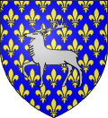 |
The arms of Pecquencourt are blazoned : Azure semy de lys Or, a stag argent. (Capelle, Loffre, Neuville-Saint-Rémy, Pecquencourt, and Vred use the same arms.)
|
Sister cities[]
 Sondershausen, Germany[3]
See also[]
References[]
- ^ "Répertoire national des élus: les maires". data.gouv.fr, Plateforme ouverte des données publiques françaises (in French). 2 December 2020.
- ^ "Populations légales 2018". INSEE. 28 December 2020.
- ^ "Partnerstädte". Sondershausen. Retrieved 4 May 2014.
| Wikimedia Commons has media related to Pecquencourt. |
| show Authority control |
|---|
This Nord geographical article is a stub. You can help Wikipedia by . |
Categories:
- Communes of Nord (French department)
- Nord (French department) geography stubs