Preux-au-Bois
Preux-au-Bois | |
|---|---|
 Saint-Martin church | |
 Coat of arms | |
show Location of Preux-au-Bois | |
 Preux-au-Bois | |
| Coordinates: 50°09′51″N 3°39′29″E / 50.1642°N 3.6581°ECoordinates: 50°09′51″N 3°39′29″E / 50.1642°N 3.6581°E | |
| Country | France |
| Region | Hauts-de-France |
| Department | Nord |
| Arrondissement | Avesnes-sur-Helpe |
| Canton | Avesnes-sur-Helpe |
| Intercommunality | |
| Government | |
| • Mayor (2014-2020) | Jacques Ruffin |
| Area 1 | 3.99 km2 (1.54 sq mi) |
| Population (Jan. 2018)[1] | 840 |
| • Density | 210/km2 (550/sq mi) |
| Time zone | UTC+01:00 (CET) |
| • Summer (DST) | UTC+02:00 (CEST) |
| INSEE/Postal code | 59472 /59288 |
| Elevation | 139–160 m (456–525 ft) |
| 1 French Land Register data, which excludes lakes, ponds, glaciers > 1 km2 (0.386 sq mi or 247 acres) and river estuaries. | |


Preux-au-Bois is a commune in the Nord department in northern France.
Heraldry[]
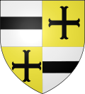 |
The arms of Preux-au-Bois are blazoned : Quarterly 1&4: Argent, a fess sable; 2&3: Or, a cross moline sable. (Bellaing, Oisy and Preux-au-Bois use the same arms.)
|
Points of interest[]
- Arboretum de l'Étang David
- There is a Commonwealth War Graves Commission cemetery just outside of the village with graves from World War I and World War II.[2]
- Statue of Louise Thuliez, a French resistance fighter during both World Wars. It was erected in 1970.[3]
See also[]
External links[]
References[]
- ^ "Populations légales 2018". INSEE. 28 December 2020.
- ^ "Preux-au-Bois Communal Cemetery". www.cwgc.org. Retrieved 27 March 2018.
- ^ Anderson, John; Pluk, Victor (2015). Trapped Behind Enemy Lines: Accounts of British Soldiers and their Protectors in the Great War. Pen and Sword. p. 51. ISBN 9781473874084.
| Wikimedia Commons has media related to Preux-au-Bois. |
| show Authority control |
|---|
This Nord geographical article is a stub. You can help Wikipedia by . |
Categories:
- Communes of Nord (French department)
- Nord (French department) geography stubs