Villereau, Nord
Villereau | |
|---|---|
 The town hall in Villereau | |
 Coat of arms | |
show Location of Villereau | |
 Villereau | |
| Coordinates: 50°14′47″N 3°41′51″E / 50.2464°N 3.6975°ECoordinates: 50°14′47″N 3°41′51″E / 50.2464°N 3.6975°E | |
| Country | France |
| Region | Hauts-de-France |
| Department | Nord |
| Arrondissement | Avesnes-sur-Helpe |
| Canton | Aulnoye-Aymeries |
| Intercommunality | Pays de Mormal |
| Government | |
| • Mayor (2020–2026) | André Fréhaut[1] |
| Area 1 | 5.52 km2 (2.13 sq mi) |
| Population (Jan. 2018)[2] | 1,021 |
| • Density | 180/km2 (480/sq mi) |
| Time zone | UTC+01:00 (CET) |
| • Summer (DST) | UTC+02:00 (CEST) |
| INSEE/Postal code | 59619 /59530 |
| Elevation | 93–149 m (305–489 ft) (avg. 135 m or 443 ft) |
| 1 French Land Register data, which excludes lakes, ponds, glaciers > 1 km2 (0.386 sq mi or 247 acres) and river estuaries. | |


Villereau is a commune in the Nord department in northern France.
Heraldry[]
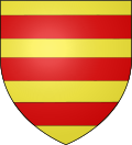 |
The arms of Villereau are blazoned : Or, 3 fesses gules. (Saint-Hilaire-lez-Cambrai, Villereau and Wallers, Rambures use the same arms.)
|
See also[]
References[]
- ^ "Répertoire national des élus: les maires". data.gouv.fr, Plateforme ouverte des données publiques françaises (in French). 2 December 2020.
- ^ "Populations légales 2018". INSEE. 28 December 2020.
| Wikimedia Commons has media related to Villereau (Nord). |
| show Authority control |
|---|
This Nord geographical article is a stub. You can help Wikipedia by . |
Categories:
- Communes of Nord (French department)
- Nord (French department) geography stubs