Vred
Vred | |
|---|---|
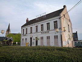 The town hall in Vred | |
 Coat of arms | |
show Location of Vred | |
 Vred | |
| Coordinates: 50°23′41″N 3°13′56″E / 50.3947°N 3.2322°ECoordinates: 50°23′41″N 3°13′56″E / 50.3947°N 3.2322°E | |
| Country | France |
| Region | Hauts-de-France |
| Department | Nord |
| Arrondissement | Douai |
| Canton | Sin-le-Noble |
| Intercommunality | Cœur d'Ostrevent |
| Government | |
| • Mayor (2020–2026) | Marie-Françoise Falempe |
| Area 1 | 3.42 km2 (1.32 sq mi) |
| Population (Jan. 2018)[1] | 1,357 |
| • Density | 400/km2 (1,000/sq mi) |
| Time zone | UTC+01:00 (CET) |
| • Summer (DST) | UTC+02:00 (CEST) |
| INSEE/Postal code | 59629 /59870 |
| Elevation | 16–20 m (52–66 ft) (avg. 18 m or 59 ft) |
| 1 French Land Register data, which excludes lakes, ponds, glaciers > 1 km2 (0.386 sq mi or 247 acres) and river estuaries. | |


Vred (French pronunciation: [vʁɛ]) is a commune in the Nord department in northern France.
Heraldry[]
 |
The arms of Vred are blazoned : Azure semy de lys Or, a stag argent. (Capelle, Loffre, Neuville-Saint-Rémy, Pecquencourt, and Vred use the same arms.)
|
See also[]
References[]
- ^ "Populations légales 2018". INSEE. 28 December 2020.
| Wikimedia Commons has media related to Vred. |
| show Authority control |
|---|
This Nord geographical article is a stub. You can help Wikipedia by . |
Categories:
- Communes of Nord (French department)
- Nord (French department) geography stubs