Beuvrages
Beuvrages | |
|---|---|
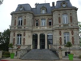 The town hall in Beuvrages | |
 Coat of arms | |
show Location of Beuvrages | |
 Beuvrages | |
| Coordinates: 50°23′12″N 3°30′23″E / 50.3867°N 3.5064°ECoordinates: 50°23′12″N 3°30′23″E / 50.3867°N 3.5064°E | |
| Country | France |
| Region | Hauts-de-France |
| Department | Nord |
| Arrondissement | Valenciennes |
| Canton | Anzin |
| Intercommunality | Communauté d'agglomération Valenciennes Métropole |
| Government | |
| • Mayor (2020–2026) | Ali Benyahia |
| Area 1 | 3 km2 (1 sq mi) |
| Population (Jan. 2018)[1] | 6,821 |
| • Density | 2,300/km2 (5,900/sq mi) |
| Time zone | UTC+01:00 (CET) |
| • Summer (DST) | UTC+02:00 (CEST) |
| INSEE/Postal code | 59079 /59192 |
| Elevation | 18–34 m (59–112 ft) (avg. 23 m or 75 ft) |
| 1 French Land Register data, which excludes lakes, ponds, glaciers > 1 km2 (0.386 sq mi or 247 acres) and river estuaries. | |


Beuvrages is a commune in the Nord department in northern France.
Population[]
|
|
Heraldry[]
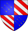 |
The arms of Beuvrages are blazoned : Quarterly 1&4: Azure, in bend sinister 3 arrows bendwise Or; 2&3: Bendy argent and gules.
|
See also[]
References[]
- ^ "Populations légales 2018". INSEE. 28 December 2020.
| Wikimedia Commons has media related to Beuvrages. |
| show Authority control |
|---|
This Nord geographical article is a stub. You can help Wikipedia by . |
Categories:
- Communes of Nord (French department)
- Nord (French department) geography stubs