Bruille-Saint-Amand
Bruille-Saint-Amand | |
|---|---|
 The ruins of the mill, and memorial | |
 Coat of arms | |
show Location of Bruille-Saint-Amand | |
 Bruille-Saint-Amand | |
| Coordinates: 50°28′24″N 3°30′03″E / 50.4733°N 3.5008°ECoordinates: 50°28′24″N 3°30′03″E / 50.4733°N 3.5008°E | |
| Country | France |
| Region | Hauts-de-France |
| Department | Nord |
| Arrondissement | Valenciennes |
| Canton | Saint-Amand-les-Eaux |
| Intercommunality | CA Porte du Hainaut |
| Government | |
| • Mayor (2020–2026) | Christophe Pannier[1] |
| Area 1 | 7.88 km2 (3.04 sq mi) |
| Population (Jan. 2018)[2] | 1,672 |
| • Density | 210/km2 (550/sq mi) |
| Time zone | UTC+01:00 (CET) |
| • Summer (DST) | UTC+02:00 (CEST) |
| INSEE/Postal code | 59114 /59199 |
| Elevation | 16–38 m (52–125 ft) (avg. 40 m or 130 ft) |
| 1 French Land Register data, which excludes lakes, ponds, glaciers > 1 km2 (0.386 sq mi or 247 acres) and river estuaries. | |


Bruille-Saint-Amand is a commune in the Nord department in northern France.
Population[]
|
|
Photos[]

Bruille Saint Amand, war memorial and church

Bruille Sint Amand, view to a street: Rue Pasteur-Rue Henri Durre
Heraldry[]
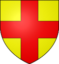 |
The arms of Bruille-Saint-Amand are blazoned : Or, a cross gules. (Bruille-Saint-Amand, Flines-lès-Mortagne, Mortagne-du-Nord and Nivelle use the same arms.)
|
See also[]
References[]
- ^ "Répertoire national des élus: les maires". data.gouv.fr, Plateforme ouverte des données publiques françaises (in French). 2 December 2020.
- ^ "Populations légales 2018". INSEE. 28 December 2020.
| Wikimedia Commons has media related to Bruille-Saint-Amand. |
| show Authority control |
|---|
This Nord geographical article is a stub. You can help Wikipedia by . |
Categories:
- Communes of Nord (French department)
- Nord (French department) geography stubs