Cysoing
Cysoing | |
|---|---|
 Cysoing in the arrondissement of Lille | |
 Coat of arms | |
show Location of Cysoing | |
 Cysoing | |
| Coordinates: 50°34′09″N 3°12′57″E / 50.5692°N 3.2158°ECoordinates: 50°34′09″N 3°12′57″E / 50.5692°N 3.2158°E | |
| Country | France |
| Region | Hauts-de-France |
| Department | Nord |
| Arrondissement | Lille |
| Canton | Templeuve |
| Intercommunality | Pévèle-Carembault |
| Government | |
| • Mayor (2020–2026) | Benjamin Dumortier[1] |
| Area 1 | 13.62 km2 (5.26 sq mi) |
| Population (Jan. 2018)[2] | 4,908 |
| • Density | 360/km2 (930/sq mi) |
| Time zone | UTC+01:00 (CET) |
| • Summer (DST) | UTC+02:00 (CEST) |
| INSEE/Postal code | 59168 /59830 |
| Elevation | 26–56 m (85–184 ft) (avg. 43 m or 141 ft) |
| 1 French Land Register data, which excludes lakes, ponds, glaciers > 1 km2 (0.386 sq mi or 247 acres) and river estuaries. | |


Cysoing (French pronunciation: [siswɛ̃]) is a commune in the Nord department in northern France, 15 km (9.3 mi) southeast of Lille. It is twinned with the English town of Much Wenlock. An obsolete spelling is Cisoin.
Heraldry[]
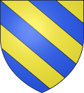 |
The arms of Cysoing are blazoned : Bendy Or and azure. (Baisieux, Bouvines and Cysoing use the same arms.)
|
Population[]
| Year | Pop. | ±% |
|---|---|---|
| 2004 | 4,318 | — |
| 2006 | 4,374 | +1.3% |
| 2007 | 4,416 | +1.0% |
| 2008 | 4,457 | +0.9% |
| 2009 | 4,499 | +0.9% |
| 2010 | 4,563 | +1.4% |
| 2011 | 4,672 | +2.4% |
| 2012 | 4,757 | +1.8% |
| 2013 | 4,836 | +1.7% |
| 2014 | 4,914 | +1.6% |
| 2015 | 4,975 | +1.2% |
| 2016 | 5,033 | +1.2% |
See also[]
- Communes of the Nord department
- Souvenir Henri Desgrange
References[]
- ^ "Répertoire national des élus: les maires". data.gouv.fr, Plateforme ouverte des données publiques françaises (in French). 2 December 2020.
- ^ "Populations légales 2018". INSEE. 28 December 2020.
| Wikimedia Commons has media related to Cysoing. |
| show Authority control |
|---|
This Nord geographical article is a stub. You can help Wikipedia by . |
Categories:
- Communes of Nord (French department)
- Nord (French department) geography stubs