Mouchin
Mouchin | |
|---|---|
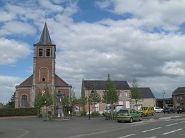 Mouchin, church | |
 Coat of arms | |
show Location of Mouchin | |
 Mouchin | |
| Coordinates: 50°31′07″N 3°17′32″E / 50.5186°N 3.2922°ECoordinates: 50°31′07″N 3°17′32″E / 50.5186°N 3.2922°E | |
| Country | France |
| Region | Hauts-de-France |
| Department | Nord |
| Arrondissement | Lille |
| Canton | Templeuve |
| Intercommunality | Pévèle-Carembault |
| Government | |
| • Mayor (2020–2026) | Christian Devaux[1] |
| Area 1 | 9.19 km2 (3.55 sq mi) |
| Population (Jan. 2018)[2] | 1,400 |
| • Density | 150/km2 (390/sq mi) |
| Time zone | UTC+01:00 (CET) |
| • Summer (DST) | UTC+02:00 (CEST) |
| INSEE/Postal code | 59419 /59310 |
| Elevation | 23–54 m (75–177 ft) (avg. 50 m or 160 ft) |
| 1 French Land Register data, which excludes lakes, ponds, glaciers > 1 km2 (0.386 sq mi or 247 acres) and river estuaries. | |


Mouchin (French pronunciation: [muʃɛ̃]) is a commune in the Nord department in northern France.
Heraldry[]
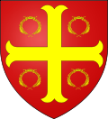 |
The arms of Mouchin are blazoned : Gules, a cross moline between 4 laurel crowns Or.
|
See also[]
References[]
- ^ "Répertoire national des élus: les maires". data.gouv.fr, Plateforme ouverte des données publiques françaises (in French). 2 December 2020.
- ^ "Populations légales 2018". INSEE. 28 December 2020.
| Wikimedia Commons has media related to Mouchin. |
| show Authority control |
|---|
This Nord geographical article is a stub. You can help Wikipedia by . |
Categories:
- Communes of Nord (French department)
- Nord (French department) geography stubs