Paillencourt
Paillencourt | |
|---|---|
 The road into Paillencourt | |
 Coat of arms | |
show Location of Paillencourt | |
 Paillencourt | |
| Coordinates: 50°14′54″N 3°16′31″E / 50.2483°N 3.2753°ECoordinates: 50°14′54″N 3°16′31″E / 50.2483°N 3.2753°E | |
| Country | France |
| Region | Hauts-de-France |
| Department | Nord |
| Arrondissement | Cambrai |
| Canton | Cambrai |
| Intercommunality | |
| Government | |
| • Mayor (2020–2026) | Fabrice Lefebvre |
| Area 1 | 7.56 km2 (2.92 sq mi) |
| Population (Jan. 2018)[1] | 1,002 |
| • Density | 130/km2 (340/sq mi) |
| Time zone | UTC+01:00 (CET) |
| • Summer (DST) | UTC+02:00 (CEST) |
| INSEE/Postal code | 59455 /59295 |
| Elevation | 32–73 m (105–240 ft) (avg. 40 m or 130 ft) |
| 1 French Land Register data, which excludes lakes, ponds, glaciers > 1 km2 (0.386 sq mi or 247 acres) and river estuaries. | |


Paillencourt (French pronunciation: [pajɑ̃kuʁ]) is a commune in the Nord department in northern France.
Heraldry[]
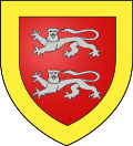 |
The arms of Paillencourt are blazoned : Gules, 2 leopards argent within a bordure Or.
|
See also[]
References[]
- ^ "Populations légales 2018". INSEE. 28 December 2020.
| Wikimedia Commons has media related to Paillencourt. |
| show Authority control |
|---|
This Nord geographical article is a stub. You can help Wikipedia by . |
Categories:
- Communes of Nord (French department)
- Nord (French department) geography stubs