Rombies-et-Marchipont
Rombies-et-Marchipont | |
|---|---|
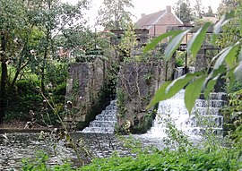 The Aunelle Valley mill in Rombies-et-Marchipont | |
 Coat of arms | |
show Location of Rombies-et-Marchipont | |
 Rombies-et-Marchipont | |
| Coordinates: 50°21′58″N 3°38′46″E / 50.366°N 3.646°ECoordinates: 50°21′58″N 3°38′46″E / 50.366°N 3.646°E | |
| Country | France |
| Region | Hauts-de-France |
| Department | Nord |
| Arrondissement | Valenciennes |
| Canton | Marly |
| Intercommunality | Communauté d'agglomération Valenciennes Métropole |
| Government | |
| • Mayor (2014-2020) | Guy Huart |
| Area 1 | 4.81 km2 (1.86 sq mi) |
| Population (Jan. 2018)[1] | 760 |
| • Density | 160/km2 (410/sq mi) |
| Time zone | UTC+01:00 (CET) |
| • Summer (DST) | UTC+02:00 (CEST) |
| INSEE/Postal code | 59505 /59990 |
| Elevation | 34–81 m (112–266 ft) (avg. 50 m or 160 ft) |
| 1 French Land Register data, which excludes lakes, ponds, glaciers > 1 km2 (0.386 sq mi or 247 acres) and river estuaries. | |


Rombies-et-Marchipont is a commune in the Nord department in northern France.
Heraldry[]
 |
The arms of Rombies-et-Marchipont are blazoned : Azure, a cross moline between 4 mullets of 6 points argent. (Rombies-et-Marchipont and Sepmeries use the same arms.)
|
See also[]
References[]
- ^ "Populations légales 2018". INSEE. 28 December 2020.
| Wikimedia Commons has media related to Rombies-et-Marchipont. |
| show Authority control |
|---|
This Nord geographical article is a stub. You can help Wikipedia by . |
Categories:
- Communes of Nord (French department)
- Nord (French department) geography stubs