Saint-Benin
Saint-Benin | |
|---|---|
 A view within Saint-Benin | |
 Coat of arms | |
show Location of Saint-Benin | |
 Saint-Benin | |
| Coordinates: 50°04′39″N 3°31′45″E / 50.0775°N 3.5292°ECoordinates: 50°04′39″N 3°31′45″E / 50.0775°N 3.5292°E | |
| Country | France |
| Region | Hauts-de-France |
| Department | Nord |
| Arrondissement | Cambrai |
| Canton | Le Cateau-Cambrésis |
| Intercommunality | CA Caudrésis - Catésis |
| Government | |
| • Mayor (2020–2026) | Véronique Nicaise[1] |
| Area 1 | 4.66 km2 (1.80 sq mi) |
| Population (Jan. 2018)[2] | 341 |
| • Density | 73/km2 (190/sq mi) |
| Time zone | UTC+01:00 (CET) |
| • Summer (DST) | UTC+02:00 (CEST) |
| INSEE/Postal code | 59531 /59360 |
| Elevation | 97–153 m (318–502 ft) |
| 1 French Land Register data, which excludes lakes, ponds, glaciers > 1 km2 (0.386 sq mi or 247 acres) and river estuaries. | |


Saint-Benin is a commune in the Nord department in northern France.
Heraldry[]
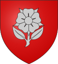 |
The arms of Saint-Benin are blazoned : Gules, a rose slipped and leaved argent. (Bazuel, Maretz and Saint-Benin use the same arms.)
|
See also[]
References[]
- ^ "Répertoire national des élus: les maires". data.gouv.fr, Plateforme ouverte des données publiques françaises (in French). 2 December 2020.
- ^ "Populations légales 2018". INSEE. 28 December 2020.
| Wikimedia Commons has media related to Saint-Benin. |
| show Authority control |
|---|
This Nord geographical article is a stub. You can help Wikipedia by . |
Categories:
- Communes of Nord (French department)
- Nord (French department) geography stubs