Wannehain
Wannehain | |
|---|---|
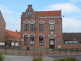 The town hall in Wannehain | |
 Coat of arms | |
show Location of Wannehain | |
 Wannehain | |
| Coordinates: 50°34′10″N 3°15′59″E / 50.5694°N 3.2664°ECoordinates: 50°34′10″N 3°15′59″E / 50.5694°N 3.2664°E | |
| Country | France |
| Region | Hauts-de-France |
| Department | Nord |
| Arrondissement | Lille |
| Canton | Templeuve |
| Intercommunality | Pévèle Carembault |
| Government | |
| • Mayor (2020–2026) | Jean-Luc Lefebvre[1] |
| Area 1 | 3.71 km2 (1.43 sq mi) |
| Population (Jan. 2018)[2] | 1,306 |
| • Density | 350/km2 (910/sq mi) |
| Time zone | UTC+01:00 (CET) |
| • Summer (DST) | UTC+02:00 (CEST) |
| INSEE/Postal code | 59638 /59830 |
| Elevation | 34–61 m (112–200 ft) (avg. 43 m or 141 ft) |
| 1 French Land Register data, which excludes lakes, ponds, glaciers > 1 km2 (0.386 sq mi or 247 acres) and river estuaries. | |


Wannehain is a commune in the Nord department in northern France, on the border with Belgium.
The HSL 1 railway line to Brussels crosses the border at Wannehain.
Heraldry[]
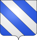 |
The arms of Wannehain are blazoned : Bendy argent and azure. (Fretin, Saultain and Wannehain use the same arms.)
|
Population[]
| Year | Pop. | ±% |
|---|---|---|
| 2006 | 913 | — |
| 2007 | 905 | −0.9% |
| 2008 | 902 | −0.3% |
| 2009 | 957 | +6.1% |
| 2010 | 1,031 | +7.7% |
| 2011 | 1,104 | +7.1% |
| 2012 | 1,155 | +4.6% |
| 2013 | 1,171 | +1.4% |
| 2014 | 1,177 | +0.5% |
| 2015 | 1,182 | +0.4% |
| 2016 | 1,188 | +0.5% |
See also[]
References[]
- ^ "Répertoire national des élus: les maires". data.gouv.fr, Plateforme ouverte des données publiques françaises (in French). 2 December 2020.
- ^ "Populations légales 2018". INSEE. 28 December 2020.
| Wikimedia Commons has media related to Wannehain. |
| show Authority control |
|---|
This Nord geographical article is a stub. You can help Wikipedia by . |
Categories:
- Communes of Nord (French department)
- Nord (French department) geography stubs