Agnez-lès-Duisans
From Wikipedia, the free encyclopedia
Commune in Hauts-de-France, France
Agnez-lès-Duisans | |
|---|---|
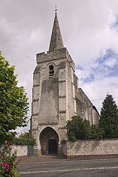 The church of Agnez-lès-Duisans | |
 Coat of arms | |
 Agnez-lès-Duisans  Agnez-lès-Duisans | |
Coordinates:  50°18′30″N 2°39′36″E / 50.3083°N 2.66°E / 50.3083; 2.66Coordinates: 50°18′30″N 2°39′36″E / 50.3083°N 2.66°E / 50.3083; 2.66 50°18′30″N 2°39′36″E / 50.3083°N 2.66°E / 50.3083; 2.66Coordinates: 50°18′30″N 2°39′36″E / 50.3083°N 2.66°E / 50.3083; 2.66 | |
| Country | France |
| Region | Hauts-de-France |
| Department | Pas-de-Calais |
| Arrondissement | Arras |
| Canton | Avesnes-le-Comte |
| Intercommunality | Campagnes de l'Artois |
| Government | |
| • Mayor (2020–2026) | Pascal Coin[1] |
| Area 1 | 7.3 km2 (2.8 sq mi) |
| Population (Jan. 2018)[2] | 649 |
| • Density | 89/km2 (230/sq mi) |
| Time zone | UTC+01:00 (CET) |
| • Summer (DST) | UTC+02:00 (CEST) |
| INSEE/Postal code | 62011 /62161 |
| Elevation | 67–111 m (220–364 ft) (avg. 70 m or 230 ft) |
| 1 French Land Register data, which excludes lakes, ponds, glaciers > 1 km2 (0.386 sq mi or 247 acres) and river estuaries. | |

Agnez-lès-Duisans is a commune in the Pas-de-Calais department in northern France.
Geography[]
A farming village located 4 miles (6 km) west of Arras, at the D62 and D56 road junction.
Population[]
| Year | Pop. | ±% |
|---|---|---|
| 2006 | 674 | — |
| 2007 | 677 | +0.4% |
| 2008 | 677 | +0.0% |
| 2009 | 688 | +1.6% |
| 2010 | 675 | −1.9% |
| 2011 | 661 | −2.1% |
| 2012 | 648 | −2.0% |
| 2013 | 643 | −0.8% |
| 2014 | 640 | −0.5% |
| 2015 | 644 | +0.6% |
| 2016 | 649 | +0.8% |
Sights[]
- The church of St.Martin, dating from the fifteenth century.
- The remains of an old castle.
- Two 18th century farm buildings.
See also[]
Communes of the Pas-de-Calais department
References[]
- ^ "Répertoire national des élus: les maires". data.gouv.fr, Plateforme ouverte des données publiques françaises (in French). 2 December 2020.
- ^ "Populations légales 2018". INSEE. 28 December 2020.
| Wikimedia Commons has media related to Agnez-lès-Duisans. |
show
Communes of the Pas-de-Calais department | |
|---|---|
|
This Pas-de-Calais geographical article is a stub. You can help Wikipedia by . |
- v
- t
Retrieved from ""
Categories:
- Communes of Pas-de-Calais
- Pas-de-Calais geography stubs
Hidden categories:
- CS1 French-language sources (fr)
- Articles with short description
- Short description is different from Wikidata
- Coordinates on Wikidata
- Pages using infobox settlement with image map1 but not image map
- Commons category link is on Wikidata
- AC with 0 elements
- All stub articles
- Pages using the Kartographer extension