Brias
Brias | |
|---|---|
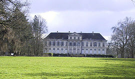 The château of Bryas | |
 Coat of arms | |
Location of Brias  | |
 Brias | |
| Coordinates: 50°24′34″N 2°22′56″E / ��50.4094°N 2.3822°ECoordinates: 50°24′34″N 2°22′56″E / 50.4094°N 2.3822°E | |
| Country | France |
| Region | Hauts-de-France |
| Department | Pas-de-Calais |
| Arrondissement | Arras |
| Canton | Saint-Pol-sur-Ternoise |
| Intercommunality | CC Ternois |
| Government | |
| • Mayor (2020–2026) | Cédric Demoulin[1] |
| Area 1 | 7.74 km2 (2.99 sq mi) |
| Population (Jan. 2018)[2] | 291 |
| • Density | 38/km2 (97/sq mi) |
| Time zone | UTC+01:00 (CET) |
| • Summer (DST) | UTC+02:00 (CEST) |
| INSEE/Postal code | 62180 /62130 |
| Elevation | 122–166 m (400–545 ft) (avg. 160 m or 520 ft) |
| 1 French Land Register data, which excludes lakes, ponds, glaciers > 1 km2 (0.386 sq mi or 247 acres) and river estuaries. | |


Brias (French pronunciation: [bʁija]; West Flemish: Briast) is a commune in the Pas-de-Calais department in the Hauts-de-France region in northern France.
Geography[]
A farming village located 22 miles (35 km) northwest of Arras on the N41 road, at the junction with the D81.
History[]
First mentioned in 1212, as the fiefdom of Gille de la Tourette.
The château of Bryas served as headquarters for Marshal Foch during the Second Battle of Artois, in 1915.
The commune agreed to change the spelling of the name from Bryas in 1997.
Population[]
| Year | Pop. | ±% |
|---|---|---|
| 1962 | 223 | — |
| 1968 | 269 | +20.6% |
| 1975 | 264 | −1.9% |
| 1982 | 278 | +5.3% |
| 1990 | 264 | −5.0% |
| 1999 | 235 | −11.0% |
| 2009 | 297 | +26.4% |
Sights[]
- The church of St. Martin
- The château, rebuilt between 1789 and 1805
See also[]
References[]
- ^ "Répertoire national des élus: les maires". data.gouv.fr, Plateforme ouverte des données publiques françaises (in French). 9 August 2021.
- ^ "Populations légales 2018". The National Institute of Statistics and Economic Studies. 28 December 2020.
| Wikimedia Commons has media related to Brias. |
This Arras arrondissement, Pas-de-Calais geographical article is a stub. You can help Wikipedia by . |
Categories:
- Communes of Pas-de-Calais
- Arras arrondissement geography stubs