Wailly
From Wikipedia, the free encyclopedia
Commune in Hauts-de-France, France
Wailly | |
|---|---|
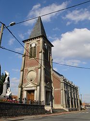 The church of Wailly | |
 Coat of arms | |
 Wailly  Wailly | |
Coordinates:  50°14′50″N 2°43′24″E / 50.2472°N 2.7233°E / 50.2472; 2.7233Coordinates: 50°14′50″N 2°43′24″E / 50.2472°N 2.7233°E / 50.2472; 2.7233 50°14′50″N 2°43′24″E / 50.2472°N 2.7233°E / 50.2472; 2.7233Coordinates: 50°14′50″N 2°43′24″E / 50.2472°N 2.7233°E / 50.2472; 2.7233 | |
| Country | France |
| Region | Hauts-de-France |
| Department | Pas-de-Calais |
| Arrondissement | Arras |
| Canton | Arras-1 |
| Intercommunality | CU Arras |
| Government | |
| • Mayor (2020–2026) | Michaël Audegond |
| Area 1 | 9.83 km2 (3.80 sq mi) |
| Population (Jan. 2018)[1] | 1,091 |
| • Density | 110/km2 (290/sq mi) |
| Time zone | UTC+01:00 (CET) |
| • Summer (DST) | UTC+02:00 (CEST) |
| INSEE/Postal code | 62869 /62217 |
| Elevation | 68–111 m (223–364 ft) (avg. 84 m or 276 ft) |
| 1 French Land Register data, which excludes lakes, ponds, glaciers > 1 km2 (0.386 sq mi or 247 acres) and river estuaries. | |

Wailly is a commune in the Pas-de-Calais department in the Hauts-de-France region of France.
Geography[]
Wailly is situated some 4 miles (6.4 km) southwest of Arras, at the junction of the D3 and the C1 roads.
Population[]
| Year | Pop. | ±% |
|---|---|---|
| 2004 | 999 | — |
| 2006 | 1,004 | +0.5% |
| 2007 | 1,010 | +0.6% |
| 2008 | 1,017 | +0.7% |
| 2009 | 1,023 | +0.6% |
| 2010 | 1,037 | +1.4% |
| 2011 | 1,045 | +0.8% |
| 2012 | 1,062 | +1.6% |
| 2013 | 1,079 | +1.6% |
| 2014 | 1,096 | +1.6% |
| 2015 | 1,105 | +0.8% |
| 2016 | 1,107 | +0.2% |
Places of interest[]
- Wailly Chateau.
- The church of St.Pierre, rebuilt after 1918.
- The Commonwealth War Graves Commission cemetery.
See also[]
References[]
- ^ "Populations légales 2018". INSEE. 28 December 2020.
External links[]
| Wikimedia Commons has media related to Wailly. |
show
Communes of the Pas-de-Calais department | |
|---|---|
|
This Arras arrondissement, Pas-de-Calais geographical article is a stub. You can help Wikipedia by . |
- v
- t
Retrieved from ""
Categories:
- Communes of Pas-de-Calais
- Arras arrondissement geography stubs
Hidden categories:
- Articles with short description
- Short description is different from Wikidata
- Infobox mapframe without OSM relation ID on Wikidata
- Coordinates on Wikidata
- Pages using infobox settlement with image map1 but not image map
- Commons category link from Wikidata
- Articles with BNF identifiers
- All stub articles
- Pages using the Kartographer extension