Boubers-lès-Hesmond
From Wikipedia, the free encyclopedia
Commune in Hauts-de-France, France
Boubers-lès-Hesmond | |
|---|---|
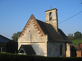 The church of Boubers-lès-Hesmond | |
 Coat of arms | |
 Boubers-lès-Hesmond  Boubers-lès-Hesmond | |
Coordinates:  50°28′34″N 1°57′00″E / 50.4761°N 1.95°E / 50.4761; 1.95Coordinates: 50°28′34″N 1°57′00″E / 50.4761°N 1.95°E / 50.4761; 1.95 50°28′34″N 1°57′00″E / 50.4761°N 1.95°E / 50.4761; 1.95Coordinates: 50°28′34″N 1°57′00″E / 50.4761°N 1.95°E / 50.4761; 1.95 | |
| Country | France |
| Region | Hauts-de-France |
| Department | Pas-de-Calais |
| Arrondissement | Montreuil |
| Canton | Auxi-le-Château |
| Intercommunality | CC Sept Vallées |
| Government | |
| • Mayor (2020–2026) | Francis Tetard[1] |
| Area 1 | 1.74 km2 (0.67 sq mi) |
| Population (Jan. 2018)[2] | 84 |
| • Density | 48/km2 (130/sq mi) |
| Time zone | UTC+01:00 (CET) |
| • Summer (DST) | UTC+02:00 (CEST) |
| INSEE/Postal code | 62157 /62990 |
| Elevation | 46–132 m (151–433 ft) (avg. 53 m or 174 ft) |
| 1 French Land Register data, which excludes lakes, ponds, glaciers > 1 km2 (0.386 sq mi or 247 acres) and river estuaries. | |

Boubers-lès-Hesmond is a commune in the Pas-de-Calais département in the Hauts-de-France region in northern France.
Contents
Geography[]
Boubers-lès-Hesmond is a small village situated some 10 miles (16 km) east of Montreuil-sur-Mer on the D149 road.
Population[]
| Year | Pop. | ±% |
|---|---|---|
| 1962 | 80 | — |
| 1968 | 90 | +12.5% |
| 1975 | 85 | −5.6% |
| 1982 | 71 | −16.5% |
| 1990 | 71 | +0.0% |
| 1999 | 77 | +8.5% |
| 2009 | 71 | −7.8% |
| 2010 | 72 | +1.4% |
See also[]
References[]
- ^ "Répertoire national des élus: les maires". data.gouv.fr, Plateforme ouverte des données publiques françaises (in French). 2 December 2020. Retrieved 7 December 2020.
- ^ "Populations légales 2018". INSEE. 28 December 2020.
| Wikimedia Commons has media related to Boubers-lès-Hesmond. |
show
Communes of the Pas-de-Calais department | |
|---|---|
|
This Pas-de-Calais geographical article is a stub. You can help Wikipedia by . |
- v
- t
Retrieved from ""
Categories:
- Communes of Pas-de-Calais
- Pas-de-Calais geography stubs
Hidden categories:
- CS1 French-language sources (fr)
- Articles with short description
- Short description is different from Wikidata
- Coordinates on Wikidata
- Pages using infobox settlement with image map1 but not image map
- Commons category link is on Wikidata
- AC with 0 elements
- All stub articles
- Pages using the Kartographer extension