Ecquedecques
Ecquedecques
Eskeldeke | |
|---|---|
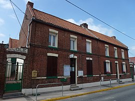 The town hall and school of Ecquedecques | |
 Coat of arms | |
show Location of Ecquedecques | |
 Ecquedecques | |
| Coordinates: 50°33′42″N 2°26′56″E / 50.5617°N 2.4489°ECoordinates: 50°33′42″N 2°26′56″E / 50.5617°N 2.4489°E | |
| Country | France |
| Region | Hauts-de-France |
| Department | Pas-de-Calais |
| Arrondissement | Béthune |
| Canton | Lillers |
| Intercommunality | CA Béthune-Bruay, Artois-Lys Romane |
| Government | |
| • Mayor (2008–2014) | Émile Flan |
| Area 1 | 2.63 km2 (1.02 sq mi) |
| Population (Jan. 2018)[1] | 507 |
| • Density | 190/km2 (500/sq mi) |
| Time zone | UTC+01:00 (CET) |
| • Summer (DST) | UTC+02:00 (CEST) |
| INSEE/Postal code | 62286 /62190 |
| Elevation | 26–75 m (85–246 ft) (avg. 33 m or 108 ft) |
| 1 French Land Register data, which excludes lakes, ponds, glaciers > 1 km2 (0.386 sq mi or 247 acres) and river estuaries. | |


Ecquedecques (West Flemish: Eskeldeke) is a commune in the Pas-de-Calais department in the Hauts-de-France region of France.
Geography[]
A farming village some 9 miles (14.5 km) southwest of Béthune and 30 miles (48.3 km) southwest of Lille, at the junction of the D185 and the D185E roads. The A26 autoroute passes by just a few yards from the commune.
Population[]
| Year | 1962 | 1968 | 1975 | 1982 | 1990 | 1999 |
|---|---|---|---|---|---|---|
| Population | 379 | 428 | 399 | 420 | 410 | 407 |
| From the year 1962 on: No double counting—residents of multiple communes (e.g. students and military personnel) are counted only once. | ||||||
Places of interest[]
- The church of St.Omer, dating from the fifteenth century.
See also[]
References[]
- ^ "Populations légales 2018". INSEE. 28 December 2020.
| Wikimedia Commons has media related to Ecquedecques. |
This Pas-de-Calais geographical article is a stub. You can help Wikipedia by . |
Categories:
- Communes of Pas-de-Calais
- Pas-de-Calais geography stubs