Ledinghem
From Wikipedia, the free encyclopedia
Not to be confused with Ledringhem, a village in the Nord department.
Commune in Hauts-de-France, France
Ledinghem
Ledingem | |
|---|---|
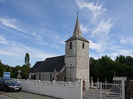 The church of Ledinghem | |
 Coat of arms | |
Location of Ledinghem  | |
 Ledinghem  Ledinghem | |
| Coordinates: 50°39′15″N 1°59′35″E / 50.6542°N 1.9931°E / 50.6542; 1.9931Coordinates: 50°39′15″N 1°59′35″E / 50.6542°N 1.9931°E / 50.6542; 1.9931 | |
| Country | France |
| Region | Hauts-de-France |
| Department | Pas-de-Calais |
| Arrondissement | Saint-Omer |
| Canton | Lumbres |
| Intercommunality | Pays de Lumbres |
| Government | |
| • Mayor (2020–2026) | Olivier Dufour |
| Area 1 | 8.68 km2 (3.35 sq mi) |
| Population (Jan. 2018)[1] | 334 |
| • Density | 38/km2 (100/sq mi) |
| Time zone | UTC+01:00 (CET) |
| • Summer (DST) | UTC+02:00 (CEST) |
| INSEE/Postal code | 62495 /62380 |
| Elevation | 100–202 m (328–663 ft) (avg. 122 m or 400 ft) |
| 1 French Land Register data, which excludes lakes, ponds, glaciers > 1 km2 (0.386 sq mi or 247 acres) and river estuaries. | |
Ledinghem (West Flemish: Ledingem) is a commune in the Pas-de-Calais department in the Hauts-de-France region of France.
Geography[]
Ledinghem is situated 12 miles (19 km) southwest of Saint-Omer, on the D128 road.
Population[]
| Year | 1962 | 1968 | 1975 | 1982 | 1990 | 1999 | 2006 |
|---|---|---|---|---|---|---|---|
| Population | 195 | 230 | 227 | 202 | 208 | 207 | 240 |
| From the year 1962 on: No double counting—residents of multiple communes (e.g. students and military personnel) are counted only once. | |||||||
Places of interest[]
- The church of St. Folquin, dating from the seventeenth century.
- The remains (motte and moat) of an old chateau.
See also[]
References[]
- ^ "Populations légales 2018". INSEE. 28 December 2020.
| Wikimedia Commons has media related to Ledinghem. |
Communes of the Pas-de-Calais department | |
|---|---|
|
This Pas-de-Calais geographical article is a stub. You can help Wikipedia by . |
- v
- t
Retrieved from ""
Categories:
- Communes of Pas-de-Calais
- Pas-de-Calais geography stubs
Hidden categories:
- Articles with short description
- Short description is different from Wikidata
- Coordinates on Wikidata
- Pages using infobox settlement with image map1 but not image map
- Articles containing West Flemish-language text
- Commons category link from Wikidata
- Articles with BNF identifiers
- All stub articles
- Pages using the Kartographer extension