Foufflin-Ricametz
From Wikipedia, the free encyclopedia
Commune in Hauts-de-France, France
Foufflin-Ricametz | |
|---|---|
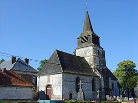 The church of Foufflin-Ricametz | |
 Coat of arms | |
 Foufflin-Ricametz  Foufflin-Ricametz | |
Coordinates:  50°21′00″N 2°23′11″E / 50.35°N 2.3864°E / 50.35; 2.3864Coordinates: 50°21′00″N 2°23′11″E / 50.35°N 2.3864°E / 50.35; 2.3864 50°21′00″N 2°23′11″E / 50.35°N 2.3864°E / 50.35; 2.3864Coordinates: 50°21′00″N 2°23′11″E / 50.35°N 2.3864°E / 50.35; 2.3864 | |
| Country | France |
| Region | Hauts-de-France |
| Department | Pas-de-Calais |
| Arrondissement | Arras |
| Canton | Saint-Pol-sur-Ternoise |
| Intercommunality | CC Ternois |
| Government | |
| • Mayor (2008–2014) | Gérard de Magneval |
| Area 1 | 3 km2 (1 sq mi) |
| Population (Jan. 2018)[1] | 163 |
| • Density | 54/km2 (140/sq mi) |
| Time zone | UTC+01:00 (CET) |
| • Summer (DST) | UTC+02:00 (CEST) |
| INSEE/Postal code | 62348 /62130 |
| Elevation | 123–156 m (404–512 ft) (avg. 145 m or 476 ft) |
| 1 French Land Register data, which excludes lakes, ponds, glaciers > 1 km2 (0.386 sq mi or 247 acres) and river estuaries. | |

Foufflin-Ricametz is a commune in the Pas-de-Calais department in the Hauts-de-France region of France.
Geography[]
A small farming village situated 22 miles (35.4 km) northwest of Arras, at the junction of the D8 and the D8E roads.
Population[]
| Year | 1962 | 1968 | 1975 | 1982 | 1990 | 1999 |
|---|---|---|---|---|---|---|
| Population | 175 | 182 | 144 | 133 | 128 | 135 |
| From the year 1962 on: No double counting—residents of multiple communes (e.g. students and military personnel) are counted only once. | ||||||
Places of interest[]
- The church of St.Martin, dating from the thirteenth century.
- The nineteenth-century chateau.
See also[]
References[]
- ^ "Populations légales 2018". INSEE. 28 December 2020.
| Wikimedia Commons has media related to Foufflin-Ricametz. |
show
Communes of the Pas-de-Calais department | |
|---|---|
|
This Arras arrondissement, Pas-de-Calais geographical article is a stub. You can help Wikipedia by . |
- v
- t
Retrieved from ""
Categories:
- Communes of Pas-de-Calais
- Arras arrondissement geography stubs
Hidden categories:
- Articles with short description
- Short description is different from Wikidata
- Infobox mapframe without OSM relation ID on Wikidata
- Coordinates on Wikidata
- Pages using infobox settlement with image map1 but not image map
- Commons category link from Wikidata
- Articles with BNF identifiers
- All stub articles
- Pages using the Kartographer extension