Herly, Pas-de-Calais
From Wikipedia, the free encyclopedia
Commune in Hauts-de-France, France
Herly | |
|---|---|
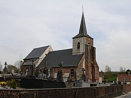 The church of Herly | |
 Coat of arms | |
 Herly  Herly | |
Coordinates:  50°33′10″N 1°59′09″E / 50.5528°N 1.9858°E / 50.5528; 1.9858Coordinates: 50°33′10″N 1°59′09″E / 50.5528°N 1.9858°E / 50.5528; 1.9858 50°33′10″N 1°59′09″E / 50.5528°N 1.9858°E / 50.5528; 1.9858Coordinates: 50°33′10″N 1°59′09″E / 50.5528°N 1.9858°E / 50.5528; 1.9858 | |
| Country | France |
| Region | Hauts-de-France |
| Department | Pas-de-Calais |
| Arrondissement | Montreuil |
| Canton | Lumbres |
| Intercommunality | CC Haut Pays du Montreuillois |
| Government | |
| • Mayor (2020–2026) | Alain Peron |
| Area 1 | 16.3 km2 (6.3 sq mi) |
| Population (Jan. 2018)[1] | 305 |
| • Density | 19/km2 (48/sq mi) |
| Time zone | UTC+01:00 (CET) |
| • Summer (DST) | UTC+02:00 (CEST) |
| INSEE/Postal code | 62437 /62650 |
| Elevation | 110–199 m (361–653 ft) (avg. 136 m or 446 ft) |
| 1 French Land Register data, which excludes lakes, ponds, glaciers > 1 km2 (0.386 sq mi or 247 acres) and river estuaries. | |

Herly is a commune in the Pas-de-Calais department in the Hauts-de-France region of France.
Geography[]
A village situated some 14 miles (22 km) northeast of Montreuil-sur-Mer on the D156 road.
Population[]
| Year | 1962 | 1968 | 1975 | 1982 | 1990 | 1999 | 2006 |
|---|---|---|---|---|---|---|---|
| Population | 389 | 407 | 404 | 413 | 326 | 323 | 325 |
| From the year 1962 on: No double counting—residents of multiple communes (e.g. students and military personnel) are counted only once. | |||||||
Places of interest[]
- The church of St.Peter, dating from the seventeenth century.
- The seventeenth century priory and chapel
See also[]
References[]
- ^ "Populations légales 2018". INSEE. 28 December 2020.
| Wikimedia Commons has media related to Herly (Pas-de-Calais). |
show
Communes of the Pas-de-Calais department | |
|---|---|
|
This Pas-de-Calais geographical article is a stub. You can help Wikipedia by . |
- v
- t
Retrieved from ""
Categories:
- Communes of Pas-de-Calais
- Pas-de-Calais geography stubs
Hidden categories:
- Articles with short description
- Short description is different from Wikidata
- Coordinates on Wikidata
- Pages using infobox settlement with image map1 but not image map
- Commons category link is on Wikidata
- Articles with BNF identifiers
- All stub articles
- Pages using the Kartographer extension