Verton
From Wikipedia, the free encyclopedia
Commune in Hauts-de-France, France
Verton | |
|---|---|
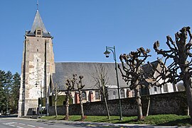 The St. Michel Church in Verton | |
 Coat of arms | |
 Verton  Verton | |
Coordinates:  50°24′10″N 1°39′00″E / 50.4028°N 1.65°E / 50.4028; 1.65Coordinates: 50°24′10″N 1°39′00″E / 50.4028°N 1.65°E / 50.4028; 1.65 50°24′10″N 1°39′00″E / 50.4028°N 1.65°E / 50.4028; 1.65Coordinates: 50°24′10″N 1°39′00″E / 50.4028°N 1.65°E / 50.4028; 1.65 | |
| Country | France |
| Region | Hauts-de-France |
| Department | Pas-de-Calais |
| Arrondissement | Montreuil |
| Canton | Berck |
| Intercommunality | CA Deux Baies en Montreuillois |
| Government | |
| • Mayor (2020–2026) | Joël Lemaire |
| Area 1 | 11.06 km2 (4.27 sq mi) |
| Population (Jan. 2018)[1] | 2,472 |
| • Density | 220/km2 (580/sq mi) |
| Time zone | UTC+01:00 (CET) |
| • Summer (DST) | UTC+02:00 (CEST) |
| INSEE/Postal code | 62849 /62180 |
| Elevation | 2–53 m (6.6–173.9 ft) (avg. 12 m or 39 ft) |
| 1 French Land Register data, which excludes lakes, ponds, glaciers > 1 km2 (0.386 sq mi or 247 acres) and river estuaries. | |

Verton is a commune in the Pas-de-Calais department in the Hauts-de-France region of France.
Geography[]
Verton is located 6 miles (9 km) southwest of Montreuil-sur-Mer at the D143 and D303 road junction, and 3 miles (5 km) from the coast, near the estuary of the Authie.
Population[]
| Year | 1962 | 1968 | 1975 | 1982 | 1990 | 1999 | 2006 |
|---|---|---|---|---|---|---|---|
| Population | 732 | 746 | 954 | 1570 | 1947 | 2123 | 2294 |
| From the year 1962 on: No double counting—residents of multiple communes (e.g. students and military personnel) are counted only once. | |||||||
Places of interest[]
- The château, dating from the fifteenth century
- The watermill
- The church of St. Michel, dating from the fourteenth century.
See also[]
References[]
- ^ "Populations légales 2018". INSEE. 28 December 2020.
| Wikimedia Commons has media related to Verton. |
show
Communes of the Pas-de-Calais department | |
|---|---|
|
This Pas-de-Calais geographical article is a stub. You can help Wikipedia by . |
- v
- t
Retrieved from ""
Categories:
- Communes of Pas-de-Calais
- Pas-de-Calais geography stubs
Hidden categories:
- Articles with short description
- Short description is different from Wikidata
- Coordinates on Wikidata
- Pages using infobox settlement with image map1 but not image map
- Commons category link from Wikidata
- Articles with BNF identifiers
- All stub articles
- Pages using the Kartographer extension