Grincourt-lès-Pas
Grincourt-lès-Pas | |
|---|---|
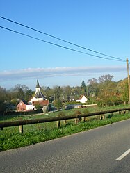 A general view of Grincourt-lès-Pas | |
 Coat of arms | |
Location of Grincourt-lès-Pas  | |
 Grincourt-lès-Pas | |
| Coordinates: 50°10′10″N 2°29′40″E / 50.1694°N 2.4944°ECoordinates: 50°10′10″N 2°29′40″E / 50.1694°N 2.4944°E | |
| Country | France |
| Region | Hauts-de-France |
| Department | Pas-de-Calais |
| Arrondissement | Arras |
| Canton | Avesnes-le-Comte |
| Intercommunality | CC Campagnes de l'Artois |
| Government | |
| • Mayor (2020–2026) | Benoît Francois[1] |
| Area 1 | 2.79 km2 (1.08 sq mi) |
| Population (Jan. 2018)[2] | 30 |
| • Density | 11/km2 (28/sq mi) |
| Time zone | UTC+01:00 (CET) |
| • Summer (DST) | UTC+02:00 (CEST) |
| INSEE/Postal code | 62389 /62760 |
| Elevation | 100–166 m (328–545 ft) (avg. 149 m or 489 ft) |
| 1 French Land Register data, which excludes lakes, ponds, glaciers > 1 km2 (0.386 sq mi or 247 acres) and river estuaries. | |


Grincourt-lès-Pas is a commune in the Pas-de-Calais department in the Hauts-de-France region of France.
Geography[]
A very small farming village situated 18 miles (29.0 km) southwest of Arras, at the junction of the D25 and the D25E roads.
Population[]
| Year | Pop. | ±% p.a. |
|---|---|---|
| 1968 | 55 | — |
| 1975 | 45 | −2.83% |
| 1982 | 55 | +2.91% |
| 1990 | 55 | +0.00% |
| 1999 | 39 | −3.75% |
| 2007 | 42 | +0.93% |
| 2012 | 37 | −2.50% |
| 2017 | 30 | −4.11% |
| Source: INSEE[3] | ||
Places of interest[]
- The church of Notre-Dame, dating from the seventeenth century.
See also[]
References[]
- ^ "Répertoire national des élus: les maires". data.gouv.fr, Plateforme ouverte des données publiques françaises (in French). 9 August 2021.
- ^ "Populations légales 2018". The National Institute of Statistics and Economic Studies. 28 December 2020.
- ^ Population en historique depuis 1968, INSEE
| Wikimedia Commons has media related to Grincourt-lès-Pas. |
This Arras arrondissement, Pas-de-Calais geographical article is a stub. You can help Wikipedia by . |
Categories:
- Communes of Pas-de-Calais
- Arras arrondissement geography stubs