Estréelles
Estréelles | |
|---|---|
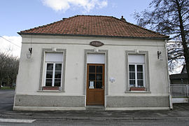 The town hall of Estréelles | |
 Coat of arms | |
show Location of Estréelles | |
 Estréelles | |
| Coordinates: 50°29′59″N 1°47′05″E / 50.4997°N 1.7847°ECoordinates: 50°29′59″N 1°47′05″E / 50.4997°N 1.7847°E | |
| Country | France |
| Region | Hauts-de-France |
| Department | Pas-de-Calais |
| Arrondissement | Montreuil |
| Canton | Berck |
| Intercommunality | CA Deux Baies en Montreuillois |
| Government | |
| • Mayor (2020–2026) | Hubert Maquaire |
| Area 1 | 3.18 km2 (1.23 sq mi) |
| Population (Jan. 2018)[1] | 350 |
| • Density | 110/km2 (290/sq mi) |
| Time zone | UTC+01:00 (CET) |
| • Summer (DST) | UTC+02:00 (CEST) |
| INSEE/Postal code | 62315 /62170 |
| Elevation | 5–79 m (16–259 ft) (avg. 10 m or 33 ft) |
| 1 French Land Register data, which excludes lakes, ponds, glaciers > 1 km2 (0.386 sq mi or 247 acres) and river estuaries. | |


Estréelles is a commune in the Pas-de-Calais department in the Hauts-de-France region of France.
Geography[]
A village situated some 3 miles (5 km) northeast of Montreuil-sur-Mer at the D127 road.
Population[]
| Year | 1962 | 1968 | 1975 | 1982 | 1990 | 1999 |
|---|---|---|---|---|---|---|
| Population | 157 | 164 | 163 | 176 | 229 | 269 |
| From the year 1962 on: No double counting—residents of multiple communes (e.g. students and military personnel) are counted only once. | ||||||
Places of interest[]
- The seventeenth century church of Saint Omer
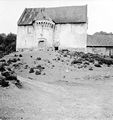
- The former Protestant church of the late 15th century, which was demolished in 1970. Foundations of chequered sandstone and carved flint are all that remain.

The Protestant church, known as "The fort".
Front view

Side view

From the valley

During demolition, in 1970

An artist's impression

Newspaper article
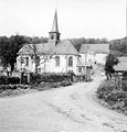
The village church


See also[]
References[]
- ^ "Populations légales 2018". INSEE. 28 December 2020.
| Wikimedia Commons has media related to Estréelles. |
| show Authority control |
|---|
This Pas-de-Calais geographical article is a stub. You can help Wikipedia by . |
Categories:
- Communes of Pas-de-Calais
- Pas-de-Calais geography stubs