Merck-Saint-Liévin
Merck-Saint-Liévin | |
|---|---|
 Aa river | |
 Coat of arms | |
show Location of Merck-Saint-Liévin | |
 Merck-Saint-Liévin | |
| Coordinates: 50°37′40″N 2°06′55″E / 50.6278°N 2.1153°ECoordinates: 50°37′40″N 2°06′55″E / 50.6278°N 2.1153°E | |
| Country | France |
| Region | Hauts-de-France |
| Department | Pas-de-Calais |
| Arrondissement | Saint-Omer |
| Canton | Fruges |
| Intercommunality | Pays de Saint-Omer |
| Government | |
| • Mayor (2020–2026) | Philippe Hochart |
| Area 1 | 11.85 km2 (4.58 sq mi) |
| Population (Jan. 2018)[1] | 659 |
| • Density | 56/km2 (140/sq mi) |
| Time zone | UTC+01:00 (CET) |
| • Summer (DST) | UTC+02:00 (CEST) |
| INSEE/Postal code | 62569 /62560 |
| Elevation | 56–172 m (184–564 ft) (avg. 68 m or 223 ft) |
| 1 French Land Register data, which excludes lakes, ponds, glaciers > 1 km2 (0.386 sq mi or 247 acres) and river estuaries. | |


Merck-Saint-Liévin is a commune in the Pas-de-Calais department in the Hauts-de-France region of France.
Geography[]
Merck-Saint-Liévin lies about 10 miles (16 km) southwest of Saint-Omer, on the D225 roads. The river Aa flows through the village.
Toponym[]
The name apparently refers to Saint Livinus of Ghent (martyred in 657 or 663), an Irish bishop who evangelized Flanders and Brabant, and is highly venerated in northern France.
Population[]
| Year | Pop. | ±% p.a. |
|---|---|---|
| 1968 | 550 | — |
| 1975 | 547 | −0.08% |
| 1982 | 514 | −0.88% |
| 1990 | 517 | +0.07% |
| 1999 | 507 | −0.22% |
| 2007 | 569 | +1.45% |
| 2012 | 620 | +1.73% |
| 2017 | 656 | +1.14% |
| Source: INSEE[2] | ||
Places of interest[]
- An eighteenth-century mill.
- The church of St. Omer, dating from the seventeenth century

View from the south

Cemetery gate
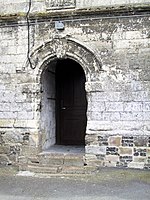
The side entrance
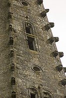
Features on the spire
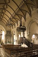
The nave

The font


See also[]
References[]
- ^ "Populations légales 2018". INSEE. 28 December 2020.
- ^ Population en historique depuis 1968, INSEE
External links[]
| Wikimedia Commons has media related to Merck-Saint-Liévin. |
- Merck-Saint-Liévin on the Insee website (in French)
| show Authority control |
|---|
This Pas-de-Calais geographical article is a stub. You can help Wikipedia by . |
Categories:
- Communes of Pas-de-Calais
- Pas-de-Calais geography stubs