Manin, Pas-de-Calais
From Wikipedia, the free encyclopedia
Commune in Hauts-de-France, France
Manin
Manning | |
|---|---|
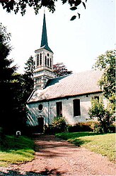 The church of Manin | |
 Coat of arms | |
 Manin  Manin | |
Coordinates:  50°17′54″N 2°30′43″E / 50.2983°N 2.5119°E / 50.2983; 2.5119Coordinates: 50°17′54″N 2°30′43″E / 50.2983°N 2.5119°E / 50.2983; 2.5119 50°17′54″N 2°30′43″E / 50.2983°N 2.5119°E / 50.2983; 2.5119Coordinates: 50°17′54″N 2°30′43″E / 50.2983°N 2.5119°E / 50.2983; 2.5119 | |
| Country | France |
| Region | Hauts-de-France |
| Department | Pas-de-Calais |
| Arrondissement | Arras |
| Canton | Avesnes-le-Comte |
| Intercommunality | CC Campagnes de l'Artois |
| Government | |
| • Mayor (2008–2014) | Gérard Mayeur |
| Area 1 | 4.07 km2 (1.57 sq mi) |
| Population (Jan. 2018)[1] | 184 |
| • Density | 45/km2 (120/sq mi) |
| Time zone | UTC+01:00 (CET) |
| • Summer (DST) | UTC+02:00 (CEST) |
| INSEE/Postal code | 62544 /62810 |
| Elevation | 113–152 m (371–499 ft) (avg. 125 m or 410 ft) |
| 1 French Land Register data, which excludes lakes, ponds, glaciers > 1 km2 (0.386 sq mi or 247 acres) and river estuaries. | |

Manin (West Flemish: Manning) is a commune in the Pas-de-Calais department in the Hauts-de-France region of France.
Geography[]
Manin is situated 15 miles (24 km) west of Arras, at the junction of the D8 and the D78 roads.
Population[]
| Year | 1962 | 1968 | 1975 | 1982 | 1990 | 1999 | 2006 |
|---|---|---|---|---|---|---|---|
| Population | 143 | 149 | 146 | 151 | 158 | 178 | 190 |
| From the year 1962 on: No double counting—residents of multiple communes (e.g. students and military personnel) are counted only once. | |||||||
Places of interest[]
- The church of St.Maclou, dating from the eighteenth century.
- An eighteenth-century chateau.

The château at Manin
See also[]
References[]
- ^ "Populations légales 2018". INSEE. 28 December 2020.
| Wikimedia Commons has media related to Manin. |
show
Communes of the Pas-de-Calais department | |
|---|---|
|
This Arras arrondissement, Pas-de-Calais geographical article is a stub. You can help Wikipedia by . |
- v
- t
Retrieved from ""
Categories:
- Communes of Pas-de-Calais
- Arras arrondissement geography stubs
Hidden categories:
- Articles with short description
- Short description is different from Wikidata
- Infobox mapframe without OSM relation ID on Wikidata
- Coordinates on Wikidata
- Pages using infobox settlement with image map1 but not image map
- Articles containing West Flemish-language text
- Commons category link is on Wikidata
- Articles with BNF identifiers
- All stub articles
- Pages using the Kartographer extension