Bancourt
From Wikipedia, the free encyclopedia
Commune in Hauts-de-France, France
Bancourt | |
|---|---|
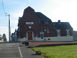 The town hall of Bancourt | |
 Coat of arms | |
 Bancourt  Bancourt | |
Coordinates:  50°06′05″N 2°53′20″E / 50.1014°N 2.8889°E / 50.1014; 2.8889Coordinates: 50°06′05″N 2°53′20″E / 50.1014°N 2.8889°E / 50.1014; 2.8889 50°06′05″N 2°53′20″E / 50.1014°N 2.8889°E / 50.1014; 2.8889Coordinates: 50°06′05″N 2°53′20″E / 50.1014°N 2.8889°E / 50.1014; 2.8889 | |
| Country | France |
| Region | Hauts-de-France |
| Department | Pas-de-Calais |
| Arrondissement | Arras |
| Canton | Bapaume |
| Intercommunality | Communauté de communes du Sud-Artois |
| Government | |
| • Mayor (2020–2026) | Bernard Rousere |
| Area 1 | 4.54 km2 (1.75 sq mi) |
| Population (Jan. 2018)[1] | 87 |
| • Density | 19/km2 (50/sq mi) |
| Time zone | UTC+01:00 (CET) |
| • Summer (DST) | UTC+02:00 (CEST) |
| INSEE/Postal code | 62079 /62450 |
| Elevation | 104–132 m (341–433 ft) (avg. 114 m or 374 ft) |
| 1 French Land Register data, which excludes lakes, ponds, glaciers > 1 km2 (0.386 sq mi or 247 acres) and river estuaries. | |

Bancourt is a commune in the Pas-de-Calais department in the Hauts-de-France region in northern France.
Geography[]
A small farming village located 10 miles (16 km) south of Arras at the junction of the D7 and D7E1 roads.
Population[]
| Year | Pop. | ±% |
|---|---|---|
| 1962 | 116 | — |
| 1968 | 123 | +6.0% |
| 1975 | 114 | −7.3% |
| 1982 | 112 | −1.8% |
| 1990 | 101 | −9.8% |
| 1999 | 95 | −5.9% |
| 2006 | 81 | −14.7% |
| 2009 | 74 | −8.6% |
| 2011 | 81 | +9.5% |
| 2015 | 84 | +3.7% |
Sights[]
- The church of St. Remi, rebuilt, like the village, after 1918.
- The Bancourt British Cemetery.
See also[]
References[]
- ^ "Populations légales 2018". INSEE. 28 December 2020.
External links[]
| Wikimedia Commons has media related to Bancourt. |
show
Communes of the Pas-de-Calais department | |
|---|---|
|
This Arras arrondissement, Pas-de-Calais geographical article is a stub. You can help Wikipedia by . |
- v
- t
Retrieved from ""
Categories:
- Communes of Pas-de-Calais
- Arras arrondissement geography stubs
Hidden categories:
- Articles with short description
- Short description is different from Wikidata
- Coordinates on Wikidata
- Pages using infobox settlement with image map1 but not image map
- Commons category link is on Wikidata
- Articles with BNF identifiers
- All stub articles
- Pages using the Kartographer extension