Tangry
From Wikipedia, the free encyclopedia
Commune in Hauts-de-France, France
Tangry | |
|---|---|
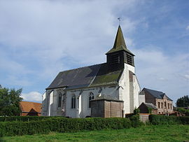 The church of Tangry | |
 Coat of arms | |
 Tangry  Tangry | |
Coordinates:  50°27′57″N 2°21′18″E / 50.4658°N 2.355°E / 50.4658; 2.355Coordinates: 50°27′57″N 2°21′18″E / 50.4658°N 2.355°E / 50.4658; 2.355 50°27′57″N 2°21′18″E / 50.4658°N 2.355°E / 50.4658; 2.355Coordinates: 50°27′57″N 2°21′18″E / 50.4658°N 2.355°E / 50.4658; 2.355 | |
| Country | France |
| Region | Hauts-de-France |
| Department | Pas-de-Calais |
| Arrondissement | Arras |
| Canton | Saint-Pol-sur-Ternoise |
| Intercommunality | CC Ternois |
| Government | |
| • Mayor (2020–2026) | Olivier Rigot[1] |
| Area 1 | 4.84 km2 (1.87 sq mi) |
| Population (Jan. 2018)[2] | 264 |
| • Density | 55/km2 (140/sq mi) |
| Time zone | UTC+01:00 (CET) |
| • Summer (DST) | UTC+02:00 (CEST) |
| INSEE/Postal code | 62805 /62550 |
| Elevation | 128–168 m (420–551 ft) (avg. 164 m or 538 ft) |
| 1 French Land Register data, which excludes lakes, ponds, glaciers > 1 km2 (0.386 sq mi or 247 acres) and river estuaries. | |

Tangry is a commune in the Pas-de-Calais department in the Hauts-de-France region of France.
Tangry lies c, 40 km northwest of Arras, at the junction of the D70, D77 and D99 roads.
Main sights[]
- The church of St.Omer, dating from the sixteenth century.
See also[]
References[]
- ^ "Répertoire national des élus: les maires". data.gouv.fr, Plateforme ouverte des données publiques françaises (in French). 2 December 2020.
- ^ "Populations légales 2018". INSEE. 28 December 2020.
| Wikimedia Commons has media related to Tangry. |
show
Communes of the Pas-de-Calais department | |
|---|---|
|
This Arras arrondissement, Pas-de-Calais geographical article is a stub. You can help Wikipedia by . |
- v
- t
Retrieved from ""
Categories:
- Communes of Pas-de-Calais
- Arras arrondissement geography stubs
Hidden categories:
- CS1 French-language sources (fr)
- Articles with short description
- Short description is different from Wikidata
- Infobox mapframe without OSM relation ID on Wikidata
- Coordinates on Wikidata
- Pages using infobox settlement with image map1 but not image map
- Commons category link from Wikidata
- Articles with BNF identifiers
- All stub articles
- Pages using the Kartographer extension